Olympiad tasks in geography on the topic "geography"
6th grade
(school stage).
Task number 1.
Imagine that you have three plans of the area in front of you, which were compiled by your friends - schoolchildren from other cities. Which of the following conventional signs can be found on each of the planes?
Symbols: a) swamp; b) salt marsh; c) felling; d) deciduous forest; e) arable land; f) dune sands; g) orchard); h) coniferous forest.
Cities: Arkhangelsk, Voronezh, Ashgabat.
Task number 2.
Arrange the objects listed below in order of distance from the audience you are currently in:
a) a point with zero geographical coordinates; b) the highest mountain in the world; c) the capital of Russia; d) the southernmost point of Africa.
Task number 3.
This Venetian merchant was the first European inXIIIcentury was able to penetrate into the interior of Asia. Traveling for many years, he collected information about the nature of the Pamirs, the monsoons of India, unknown plants in China. State the traveler's name.
Task number 4.
Arrange the maps in descending order of the degree of detail of the depicted territory:
a) 1: 5,000,000 b) 1: 10,000,000 c) 1: 100,000 d) 1: 200,000
Task number 5.
Writer N.N. Mikhailov (he was a geographer) in his book "I'm walking along the meridian" writes that the day lasted 180 days.
“The sun went around in a circle almost at the same height, and it was impossible to guess what time it was, or figure out which way it was south.”
What place is the author talking about?
Task number 6.
The sailors found a bottle in the sea, which contained a paper asking for help. But the water that penetrated the bottle destroyed some letters and numbers, so instead of an exact indication of the place of the tragedy, only the following fragments were preserved in the note:
“8º….sh. and ….º in…. on the island Sh….nk….Help!”
Read the sailors' note.
Task number 7.
“In the middle of our country, like a patterned belt, a ridge stretches. A thousand years ago it was called the Stone Belt. The rivers flow down from the ridge and to the west - to Europe, and to the east - to Asia.What mountains are we talking about?
Task number 8.
Knowing the latitude of pointsA B C D, determine how they are located, which one:
1) closest to the equator; 2) closest to the topic;
3) closest to the South Pole; 4) the northernmost point.
A. (43º S),B. (19º S),IN. (7º N),G. (34ºN).
Task number 9.
What meridians of the Western Hemisphere are a continuation of the 20th, 40th, 70th meridians in the Eastern Hemisphere?
All-Russian Olympiad for schoolchildren in geography
7 Class
(school stage).
Task number 1
Make pairs of correct answers "a device is a unit of measure, which characterizes the value measured by the device." What device was left without a pair? What does it show?
Instruments: anemometer, barometer, hygrometer, precipitation gauge, thermometer, echo sounder.
Units of measure: millimeter, meter, m/s, mmHg, percent.
Task number 2
Choose from the listed winds those that are called seasonal.
Trade winds, monsoons, westerly winds, breezes.
Task number 3
The city of Krasnodar is located on the 45º N latitude. What is it closer to - the equator or the North Pole? Why?
Task number 4.
Fishermen on a raft are in distress, their coordinates are 40ºS. sh. and 120º W. e. What current did the fleet fall into? Will it help people get to shore?
Task number 5.
Determine the climatic zones according to the description.
A. 1) July temperature +30…+35 ºС,
2) January temperature +15…+20 ºС,
3) precipitation less than 300 mm/year,
4) high pressure prevails.
B. 1) January temperature is about 0 º C,
2) July temperature -15…-20 ºС,
3) precipitation 400-500 mm/year (more in December - February).
B. 1) January temperature is about +10 ºС,
2) July temperature +25…+30 ºС,
3) precipitation 800-900 mm/year (more in July - August)
Task number 6.
If you sail along the coast of this continent, you can cross three oceans. What is this mainland? Give the date and names of its discoverers.
Task number 7.
These two countries are located on the same continent. Part of the border between them runs along the river. Their shores are washed by one bay, the name of which is the same as the name of one of the countries. Name all these geographic features.
Task number 8
Why are the Amazon and Congo rivers the deepest in the world?
Task number 9.
Name the unknown in these physical and geographical proportions:
1) Everest / Eurasia = ? / South America;
2) Africa / Nile = ? / Mississippi;
3) North America / Niagara Falls = ? / Victoria Falls;
4) Africa / Sahara = ? / Atacama
Task number 10.
“The mighty chest of the ocean seems to breathe, rising and falling approximately every six hours. There may be calm, but at the right time, the waves will still attack the land, flooding the shallows and coastal stones, breaking with foam near the high rocks. Another six hours will pass, and the ocean will begin to recede from the coast, leaving crustaceans, small fish, worms, algae on the sea sand or pebbles.What is this natural phenomenon? Explain its origin.
All-Russian Olympiad for schoolchildren in geography
8th grade.
(school stage).
Time to complete the work - 1 hour 30 minutes. (2 lessons).
1 round. Test. W and each correct answer is 1 point. Total 25 points
1. Which continent is crossed by the equator in the northern part?
A) North America B) South America; B) Australia D) Eurasia.
2. Relatively stable and leveled areas of the earth's crust that lie at the base of modern continents are:
A) continental shallows; B) platforms; B) seismic belts; D) islands.
3. Green plants absorb carbon dioxide and release oxygen. This is an example of an interaction:
A) hydrosphere and lithosphere; B) atmosphere and lithosphere;
C) biosphere and hydrosphere; D) biosphere and atmosphere.
4. Natural areas change from the equator to the poles, as it changes:
A) relief; B) climate; B) soil; D) the nature of human activity.
5. Which plant or animal is NOT a characteristic of the savannah zone?
A) a hippopotamus B) gorilla; B) acacia D) baobab.
6. Why was Alaska used to be called "Russian America"?
A) its nature is similar to the nature of Russia;
B) it was discovered and explored by Russian sailors;
C) its indigenous people spoke Russian;
D) Alaska - translated means "Russian".
7. What are the coordinates of the eastern point of Russia - Ratmanov Island?
A. 75°30´ N 169° 00´ E B. 55°30´ N 189° 00´ E d
E. 65°30´ N 169° 00´ W D. 175°30´ N 169° 00´ W
8. What is the MAIN value of the ozone layer for planet Earth?
A) protects the Earth from falling meteorites;
B) protects against overheating and hypothermia;
C) needed by organisms for respiration;
D) blocks harmful ultraviolet radiation.
9. Descendants from marriages of blacks and whites are called:
A) mestizos; B) sambo; B) mulattoes; D) Indians.
10. In which of the named seas of the Atlantic Ocean is oil produced?
A) in Sargasso; B) in the North; B) in the Baltic D) in the Weddell Sea.
11. Approximately how much % of the Earth's fresh water is "frozen" in the ice of Antarctica?
A) 40%; B) 50%; C) 80%; D) 90%.
12. What is the length of the continent of Eurasia from west to east in degrees, if the longitude of the westernmost point of the continent is 9 ° W, and the easternmost point is 170 ° W?
A) 161°; B) 179 °; B) 199 °; D) 189 °.
13. What is the difference between a national park and a reserve?
A) it has a large territory; B) only animals are protected in it;
C) it can be visited by tourists; D) all of the above.
14. Which natural area is characterized by the following combination natural components: chernozem soils, cereal vegetation, ground squirrels, foxes, mice, hares, bustards:
A. Tundra; B. Taiga; V. Steppes; D. Deserts.
15. With which state does Russia have the smallest land border?
A. from the DPRK; B. with Poland; V. with Norway; G. with Latvia.
16. The words: “Russian power will grow in Siberia” belongs to:
A. Peter I; B. M. V. Lomonosov; V.N.M. Przhevalsky; G. V. Tatishchev.
17. Geysers of the Far East are located:
A. on about. Wrangel; B. in Chukotka; V. In Kamchatka; G. on Taimyr.
18 . Select wrong Answer: Favorable conditions for life are:
A. Abundance of precipitation; B. Low relative humidity;
B. Warm sunny summer; D. Moderately cold winter.
19. The area of which of the continents is closest to the area occupied by Russia?
A. Australia; B. Antarctica; B. North America; D. South America.
20. Baikal accounts for 20% of fresh water reserves ... ..:
A. Russia; B. Siberia; In Eurasia; G. Mira.
21. Indicate a couple of countries that do NOT have a common border with Russia:
A. Kazakhstan - Uzbekistan; B. Kyrgyzstan - Moldova;
B. Armenia - Belarus D. Georgia - Bulgaria.
22. In this mountainous republic, two branches of the deepest river in Russia originate.
A. Tuva; B. Buryatia; V.Komi; G. Altai.
23. Which of the listed mountains in Russia are the highest?
A. Khibiny; B.Ural; V. Altai; G. Sikhote-Alin?
24. Which subject of Russia is a semi-enclave:
A. Chukotka Autonomous Okrug. B. Nenets Autonomous Okrug. V. Kaliningrad region. G. Adygea.
25. Through which strait does the border between Russia and Japan pass:
A. Beringov. B. Shokalsky. V. Korean. G. Kunashirsky.
Givebriefanswer.
№. 1 . It is known that every new day, New Year the first people on earth to meet the inhabitants of Cape Dezhnev and Fr. Ratmanov. How fast is the New Year approaching Moscow? Can a plane flying at a speed of 900 km/h overtake the approach of the new year? Justify the answer.
№2. What do quarries and heaps have in common? Where do they meet?
№3. In Karelia, "rotten" stones are often found. Hit such a boulder with a stick, and it will crumble, turn into reddish dust. Why did this strongest rock - granite "rotten"?
№4 . When summer starts"meteorological", "astronomical", "natural"? Justify your answer.
Total: Maximum - 37 points.
Answer sheet. 1 round. Test.
F.I. _____________________ ________ Class.
| № question | №1 | №2 | №3 | №4 | №5 | №6 | №7 | №8 | №9 | №10 | №11 | №12 | №13 |
| Possible answer. | |||||||||||||
| № question | №14 | №15 | №16 | №17 | №18 | №19 | №20 | №21 | №22 | №23 | №24 | №25 | |
| Possible answer |
Keys.
Geography Grade 8.
1 round. Test. Maximum - 25 points.
| № question | №1 | №2 | №3 | №4 | №5 | №6 | №7 | №8 | №9 | №10 | №11 | №12 | №13 |
| Possible answer. | B | B | G | B | B | B | IN | G | IN | B | IN | IN | IN |
| № question | №14 | №15 | №16 | №17 | №18 | №19 | №20 | №21 | №22 | №23 | №24 | №25 | |
| Possible answer | IN | A | B | IN | A | B | G | B | A | IN | IN | G |
2 round. Analytical. Maximum - 12 points.
Givebriefanswer. For each correct answer 3 points.
№1. The speed of rotation of individual points of the globe is different. To determine the speed of approaching the new year on the parallel of Moscow, you need to divide the length of the parallel (22,000 km) by 24 (22000:24). It turns out 917 km / h. This speed is somewhat higher than the flight speed of "our" aircraft and this aircraft is not able to "catch up" with the new year.
№2. Anthropogenic landforms. Construction sites and open pit mining sites; near the mines, waste heaps are formed from the waste rock.
№3. The stone "rotted" under the influence of lichens that settled on it. These plants secrete substances that corrode such durable rocks as granite. And then comes the process of soil formation, when mosses first settle on the destroyed rocks. Then bushes, then trees.
№ 4. "Meteorological" summer begins on June 1 (calendar);
"Astronomical" summer - June 22 (since the summer solstice);
"Natural" has different dates - botanists count from the beginning of the flowering of purple lilac; scattering of elm fruits; blooming meadow clover.
All-Russian Olympiad for schoolchildren in geography
Grade 9
(school stage).
Time to complete the work - 1 hour. 30 min. (2 lessons).
1 round. Test. W and each correct answer is 1 point.Only 25 points.
1. At what parallel are the polar day and polar night observed?
A). 30°S sh.; B). 50°S sh. ; IN). 23°N; D).70°N
2.Which type natural resources include forest resources?
A). Inexhaustible; B). Inexhaustible non-renewable;
IN). Exhaustible renewable; G. Exhaustible, non-renewable.
3. Specify the city that is located on the Volga River:
A). Penza; B). Tolyatti; IN). Yoshkar-Ola; G). Voronezh.
4. Country with which Russia does not have a land border:
A). Poland; B). China; IN). Moldova; G). Latvia.
5. Which city is the administrative center of the Yamalo-Nenets autonomous region?
A). Anadyr; B). Barnaul; IN). Maykop; G). Salekhard.
6. The smallest republic in area, which is part of Russia:
A). Tyva; B). Altai; IN). Adygea; G). Khakassia.
7. Name the state on the border with which the westernmost point of Russia is located:
A). Ukraine; B). Finland; IN). Poland; G). Lithuania.
8. The capital of which subject of the Russian Federation is the geographical center of Asia?
A) the Republic of Altai; B) Buryatia; B) Tyva; Trans-Baikal Territory.
9. Specify the city - millionaire:
A). Omsk; B). Vologda; B). Voronezh; G). Kirov.
10 . In Russia, a non-freezing port:
A). Petropavlovsk - Kamchatsky; B). Arkhangelsk
IN). Find G). Murmansk
11. Choose a republic within Russia, in which the people of the Iranian group of the Indo-European language family live:
A) Buryatia; B) Tyva; B) Kabardino-Balkaria; G) North Ossetia;
D) Tatarstan; E) Mordovia.
12. Which of the following peoples is the largest in terms of population in Russia?
A). Karely; B). Tatars; IN). Khanty; G).Yakuts.
13. The territory of Russia occupies:
A). northern Europe and eastern Asia B). Eastern Europe and Northern Asia
IN). western Europe and southern Asia D). southern Europe and western Asia.
14. Indicate the country on the border with which the southernmost point of Russia is located:
A). Georgia; B). China; B). Azerbaijan; G). Kazakhstan;
15. Specify the capital of the republic within Russia:
A). Astana; B). Norilsk; IN). Pskov; G). Petrozavodsk.
16. Name the country with which Russia has the longest border:
A). China; B). Mongolia; IN). Kazakhstan D). Ukraine.
17. Blue Stream pipeline laid ….
A). Through the Bering Strait to the USA; B). Through the Baltic Sea to Germany;
IN). Through the Black Sea to Turkey; G). Through the Baltic Sea to Sweden.
18. Which of the peninsulas of Russia presumably holds large reserves of gas?
A). Yamal; B). Taimyr; IN). Chukchi; G. Kolsky?
19. Where only the peoples of the Caucasus are listed:
A). Ingush, Chechens, Udmurts; B). Balkars, Chuvashs, Kalmyks.
IN). Avars, Maris, Koryaks. G). Adyghe, Ossetians, Ingush.
20. Which ocean basin does the Volga River belong to:
A). Quiet; B). the Arctic; B) the Atlantic G). internal drain.
21. The most powerful hydroelectric power station in Russia was built on the river.
A. Angara B. Volga B. Yenisei G. Bureya.
22. A river flows through the territory of the Nizhny Novgorod region:
A). Gum; B). Ugra; IN). Khoper; G). Urga.
23. In which city of the Nizhny Novgorod region is a large oil refinery located?
A). Chkalovsk: B). Pavlovo; IN). Kstovo; G). Vyksa.
24. In which city is one of the Russian leaders in river shipbuilding - the Krasnoye Sormovo plant located?
A). Cheboksary; B). Vyksa; IN). Nizhny Novgorod; G). Bor.
25. The branch of specialization of mechanical engineering in the Nizhny Novgorod region is:
A). Heavy engineering; B). Electric power engineering;
IN). Automotive; G). Agricultural engineering.
2 round. Analytical.
Givebriefanswer. For each correct answer 3 points. Maximum - 12 points.
№1 . Define a region by its brief description:
This area is located in the forest zone. It has a border position with one of the CIS countries. The most important transport routes connecting Russia with the countries of Western Europe pass through its territory. Historically, the route "from the Varangians to the Greeks" passed through its territory. The administrative center is called the "Key City". The region's economy is supplied with energy by a large modern nuclear power plant.
№2 . Arrange the seas as their salinity decreases:
A). Red; B). Baltic; IN). White; D) the Bering Sea.
Write down the resulting sequence of letters.
№3 . How to explain the greater degree of pollution of the Caspian Sea in comparison with the pollution of the waters of the Kara Sea. Give at least two reasons.
№ 4. Cities - like people, have their own names. How are the cities of Russia now called:
A). Gzhatsk; B). Khlynov; B) Tsaritsyn; G). Simbirsk; D). Kremlin.
Total: 37 points.
___________________________________________________________________
Answer sheet. 1 round. Test. F.I. _______________________________ Class.
| № question | №1 | №2 | №3 | №4 | №5 | №6 | №7 | №8 | №9 | №10 | №11 | №12 | №13 |
| Possible answer. | |||||||||||||
| № question | №14 | №15 | №16 | №17 | №18 | №19 | №20 | №21 | №22 | №23 | №24 | №25 | |
| Possible answer |
Key. Geography grade 9.
school stage All-Russian Olympiad schoolchildren
1 round. Test.
| № question | №1 | №2 | №3 | №4 | №5 | №6 | №7 | №8 | №9 | №10 | №11 | №12 | №13 |
| Possible answer. | G | IN | B | IN | G | IN | IN | IN | A | G | G | B | B |
| № question | №14 | №15 | №16 | №17 | №18 | №19 | №20 | №21 | №22 | №23 | №24 | №25 | |
| Possible answer | B | G | IN | IN | B | G | G | IN | G | IN | IN | IN |
2 round. Analytical.
№1 . Smolensk region
№2 A, D, C, B.
Red Sea - 38-42‰ Baltic - 11-6‰ White - 32-24‰ Bering 33-30‰
№3 1 . A large degree of economic development of the Caspian Sea; 2. The Caspian is a lake, there is no connection with the ocean; The Kara Sea has a connection with the Arctic Ocean
№ 4. A. Gagarin; B), Kirov; C). Volgograd; D), Ulyanovsk; D). Sarov.
School stage of the All-Russian Olympiad for schoolchildren
Olympiad 10 class
Part 1
Test round tasks
A1. Select an island that is part of Russia from the list
Askold
damansky
Serpentine
Tarabarov
A 2. On which date is the thermal equator closest to the geographic equator
January 22
March 22
22nd of June
September 22nd
A3. What landform is of anthropogenic origin?
Bulgunyakh
Ponor
Terrikon
Circus
A 4. Choose the correct ending of the statement. The age-sex structure of the Russian population is characterized by an excess of the number of men over the number of women ...
…in the middle and older age groups Oh
… in older and younger age groups
… only in the younger age group
… only in the middle age group
A 5 On which island are the capitals of the two states located?
Haiti
kalimantan
Mauritius
Samoa
A 6. Choose three capitals of the constituent entities of the Russian Federation, whose indigenous people profess one religion
Gorno-Altaisk, Naryan-Mar, Ulan-Ude
Gorno-Altaisk, Kyzyl, Elista
Gorno-Altaisk, Naryan-Mar, Kyzyl
Kyzal, Ulan-Ude, Elista
A 7. Which of the types of vegetation (landscapes) is the "black sheep" here?
Prairie
Pune
Pashta
pampas
A 8. In what direction does the southeast wind blow?
In the northwestern
In the northeast
In the southeast
In the southwestern
A 9. In the basin of which river is irrigated agriculture not widespread?
Don S. Ob
KubanD. Northern Dvina
A10. Which of the four countries has the highest population density?
India
China
Nigeria
The Republic of Korea
A11. Which center of traditional folk crafts specializes in decorative painting of wooden utensils?
gzhel
Dymkovo
Palekh
Khokhloma
A12. Which river is not characterized by significant seasonal fluctuations in flow?
Angara
Sukhona
Terek
Ussuri
A13. Where is the type of climate the same as at point 370 NL and 1220 z.d?
36 0 NL and 1400 vv.d.
33 0 S and 190 o.d.
46 0 S and 680 h.d.
41 0 S and 1750 o.d.
A14. A country that is both a giant in terms of area and population is:
Canada 2. Sudan 3. Australia 4. USA
A15. On which river is the largest city located?
Don
Irtysh
Kama
Ob
IN 1. Find a match
AT 2.
It's noon on the zero meridian, and 17 hours on the ship. What ocean is the ship sailing in?
AT 3.
Among the listed countries, find those that are simultaneously among the ten largest countries in terms of area and population:
Russia, Canada, Pakistan, Nigeria, Kazakhstan, Japan, USA, Indonesia, China, Australia, Brazil, India, Sudan. Bangladesh, Ethiopia, Mongolia.
AT 4.
Name the country, identifying it according to the list of capitals of neighboring states that have a common border with it: Berlin, Prague, Bratislava, Budapest, Ljubljana, Rome, Bern, Vaduz.
Name the form of government and form state structure this country.
C-1. This African country was a French colony in the past, and now it is a member of OPEC, one of the largest exporters of oil and gas. This is one of the few countries whose name is the same as the name of its capital. Name this country and the largest peoples inhabiting it. What part of it is the most populated and what is it connected with?
C-2. Determine which subject of the Russian Federation is in question.
This subject of the federation is located in the southern part of the penultimate (out of eleven) economic region of Russia in terms of population. Most of the territory of this subject of the federation is occupied by a zone of mixed and broad-leaved forests. Lowlands here alternate with mountainous regions. The share of Ukrainians is quite high in the structure of the population (according to the 1989 census - 8%). Almost half of the total industrial products account for one of the sectors of the food industry (in terms of the share of products of this industry, the economic region ranks first in the country). Mechanical engineering, timber and woodworking industries, mining and processing of non-ferrous metal ores are also developed. Agriculture is represented by diversified crop production, including rice growing, meat and dairy cattle breeding, fur farming, and deer breeding (spotted deer) are developed
Answers to test tasks
| Job number | Correct answer |
| A 1 | A |
| A 2 | A |
| A 3 | WITH |
| A 4 | IN |
| A 5 | IN |
| A 6 | D |
| A 7 | B |
| A 8 | A |
| A 9 | B |
| A 10 | D |
| A 11 | D |
| A 12 | B |
| A 13 | B |
| A 14 | 4 |
| A 15 | D |
For each correct answer 1 point.
Answers for the analytical round.
B 1 1-C, 2-A, 3-E, 4-A, 5-B, 6-D1 point for each correct answer, maximum 6 points
B 2 Indian Ocean 1 point
B 3 Russia, USA, China, India for each correct answer 1 point, maximum 4 points
In 4 Austria 1 point
S 1 Algeria 1 point
C 2 Primorsky Krai 1 point
Maximum for the analytical round 14 points
School stage of the All-Russian Olympiad for schoolchildren
Grade 11
Test round.
Indicate the correct pairs of "giant country in terms of population and its capital."
China - Delhi 2) Indonesia - Jakarta 3) Brazil - Rio de Janeiro 4) Pakistan - Islamabad
Which country is Brazil?
To key countries 2) to oil-producing 3) to new industrial 4) to backward
A federal state is not:
Mexico 2) Germany 3) France 4) USA 5) India
The country(s) with a republican form of government is:
1) Argentina 2) Belgium 3) Denmark 4) Nepal
5. The states that are part of the Commonwealth, headed by Great Britain, and are economically developed countries with a federal structure, are: 1) Canada 2) Bahamas 3) Antigua and Barbuda 4) Australia 5) New Zealand
6. The mainland on which there are no monarchies is: 1) Africa 2) South America 3) Australia 4) North America
7. Establish a correspondence between the state and its characteristics.
| State | Characteristic |
| Poland Canada Russia France Belarus | A) a state within the Commonwealth B) a state within the CIS B) a member state of NATO D) the largest country in the world D) one of the most developed countries in Europe |
8. Indicate the correct pairs "the state and the part of the World Ocean to which it has access."
1) Spain - Mediterranean Sea 2) Turkey - Red Sea 3) India - Bay of Bengal 4) Venezuela - Caribbean Sea 5) Ethiopia - Arabian Sea
9. Define the country by description.
This peninsular state in the form of government is a constitutional monarchy, belongs to the NIS. 1) Norway 2) Mexico 3) Thailand 4) Saudi Arabia
10. Select the group that correctly lists the largest universal ports in the world:
A) Hamburg, Antwerp, ShanghaiB) Houston, Nagoya, New York,
B) Chiba, Singapore, Yokohama,D) Rotterdam, New Orleans, Singapore
11 . The most powerful hydropower potential is possessed by:
A) China, Russia, Algeria,
B) Congo, Brazil, Canada,
B) USA, Japan, Australia,
D) Ukraine, Mexico, Iran
12. The main area of labor immigration is:
A) Southwest Asia, B) Western Europe, C) East Africa, D)CIS
13.B modern conditions the focus of ferrous metallurgy has increased: 1) on the transport flows of coal and ore 2) on rich coal deposits 3) on rich ore deposits
14. Indicate the top three countries - leaders in steel production. 1) USA 2) Russia 3) Luxembourg 4) Belgium 5) Italy 6) Japan 7) China
15. Iron ore exporting countries are: 1) Brazil 2) Australia 3) Russia 4) Germany 5) Japan 6) Great Britain 7) India 8) Canada 9) France
16. The country (s) richest in manganese ores is: 1) Malaysia 2) Bolivia 3) Australia 4) Jamaica 5) Chile
17. In which African countries have large deposits of iron ore been exploited in recent years? 1) in Libya and Algeria 2) in Liberia and Mauritania 3) in Gabon and Chad
18. The region of ferrous metallurgy in Europe is: 1) South Wales 2) Scotland 3) Normandy 4) Catalonia 5) Sicily
19. Countries in which ferrous metallurgy is developed are included in the organization (s): 1) ASEAN 2) OPEC 3) Benelux 4) ECSC
20 . Which of the following countries is characterized by subtropical agriculture, the cultivation of citrus fruits, grapes, olive trees? With which European countries does this country have a close agricultural specialization?
A) ItalyB) France;B) Great Britain;D) Germany.
Analytical Round
The ethnic composition of the population of this country is 80.7% - Walloons and Flemings, 2.4% - Germans, 2.4% - Indonesians, 2.2% - Turks, 2.0% - Surinamese, 2% - Moroccans, 1.5 % Indian, 0.8% Antillian and Aruban, and 6.0% other ethnic groups. The composition of the population of this country by religion: 31.27% - Catholics, 33% - Protestants, 6% - Muslims, 0.6% - Hindus, 0.5% - Buddhists, 2.2% profess other religions. What country is it?
This sea washes the shores of seven countries, five of which are Orthodox, one is Muslim, and another is mixed. The title languages of three countries belong to the Slavic group, one country - to the Turkic, one country - to the Romance group, one country to the Abkhaz-Adyghe and another country - to the Kartvelian. In the basin of this sea, three countries have the status of unrecognized states. Two states in the 2000s withdrew from the CIS. Name the sea, unrecognized states, their capitals and countries that left the CIS and whose shores are washed by this sea.
Identify the country by describing its neighbors. What is this state? 1) Religions such as Hinduism, Buddhism, Sikhism and Jainism originated in this country.
2) This state was previously known as East Pakistan. 3) This country ranks third in the world in terms of area. 4) The name of this state is translated as "the country of millions of elephants and a white umbrella."
A country in Southeast Asia that has never been a colony.
ATTENTION TO ALL TEACHERS: according to Federal Law No. 313-FZ, all teachers must be trained in first aid.
Olympiad tasks in geography on the topic "Geography"
Select a document from the archive to view:
Tasks municipal stage Grade 10.doc
Library
materials
Tasks for the municipal stage of the Olympiad Grade 10.
Test tasks
a) passenger traffic
b) internal migration
c) transport diagrams
d) birth and death rates
How did the Russians call the Saami?
Kyrgyzstan
Zambia
Macedonia
Bolivia
a) "urban explosion";
b) conurbation;
c) gentrification;
d) suburbanization.
Name the island:
Explain your answer.
6. Which of the following peoples profess Catholicism
a) Uighurs
b) Slovenians
c) German-Swiss
d) Croatians
d) Spaniards
7. Which of the following countries are unitary parliamentary republics
a) France
b) Germany
c) Sweden
d) Great Britain
e) Italy
8. Which of the named European states have a monarchical form of government
a) Luxembourg and San Marino
b) Spain and Liechtenstein
c) Sweden and Finland
d) Andorra and Portugal
e) Netherlands and Belgium
Not belong to NATO
a) Iceland
b) Switzerland
c) Sweden
d) Romania
e) Finland
a) Saami
b) Bosnians
c) Swedes
d) Turks
e) Hungarians
a) Latvians
b) gypsies
c) Croatians
d) Romanians
e) Macedonians
a) Greeks
b) Macedonians
c) Croatians
d) Serbs
e) Hungarians
a) the Netherlands
b) Luxembourg
c) Greece
d) Belgium
e) Finland
14. According to the agro-climatic characteristics, most of the territory of Russia belongs to the humidification zone:
1. Wet;
2. Slightly arid;
3. Arid;
4. Dry.
15. Arrange the regions of the country in the order in which their inhabitants celebrate the New Year.
1. Kamchatka Territory;
2. Altai Territory;
3. Republic of Sakha;
4. Republic of Kalmykia.
Theoretical tasks.
Exercise 1.
Each country in which the single European currency is in circulation mints its own symbols on coins - euro cents and euros. Determine which countries the listed images correspond to:
A) Oak branch with acorns, gate, heraldic eagle;
B) Trier, corvette, tanker;
C) Gentian, edelweiss, alpine primrose (primrose);
D) Profile of King Albert II;
D) Cathedral in Santiago de Compostela
Task 2.
This administrative-territorial unit (ATE) of one of the states of the world got its name in honor of the English Queen Elizabeth I, who never married. At the end of the 18th century, it was the largest ATU in its country, and now it is in the second half of the list in this indicator.
Call this ATE.
Choose the crop grown in this ATE, the quality of which is appreciated all over the world.
1. grapes, 2. tobacco, 3. peaches, 4. feijoa, 5. olives
Task 3.
due to direct military threat
Questions:
Task 4.
This has happened 7 times on earth. It is believed that the first time this happened at the beginning of the 19th century, the second - at the beginning of the 20th. The third is around 1960, and the fourth is in 1974. When this happened for the fifth time in 1987, it was decided that this event took place in Zagreb, for the sixth time in 1999 in Sarajevo, and for the seventh time in 2011 in
Kaliningrad.
What is it about?
Task 5.
According to the plan 1:5000
What characteristic of buildings are intended to reflect the numbers 5, 9, 12, etc., indicated inside the outline of each building (black rectangles and other figures)?
What does the signature on the Olshanka River 139.4/(12.VII) mean?
Can swim under the bridge on the river. Olshanka is a loaded barge with a maximum height of 8.4 m, if with a load it gives a draft of 2.7 m? Will the barge be able to return after unloading, sailing under the bridge again, if its draft is 1.3 m without cargo?
Selected document to view keys 10 cl..docx
Library
materials
Geography
Answers
Test tasks
1. - g; 2.- 3. - do not have access to the "open sea"; 4. - in; 5. - Kodiak, after the sale of Alaska, its inhabitants switched from the Julian calendar to the Gregorian; 6. - b, d, e; 7. - d; 8. - b, e; 9. - b, c, e; 10. - a, e; 11. - c, d; 12. - a, b, d; 13 - d. 4 - 1; 15 - 1324.
Theoretical tour
Exercise 1.
Answers:
A) Germany, B) Greece, C) Austria, D) Belgium, E) Spain
Task 2.
Answer: tobacco, Virginia;
Task 3.
Answers:
A) moving the capital
B) Kharkiv - Kyiv
D) Nauru
Task 4.
Task 5.
Answers
1. Number of storeys of buildings.
2. 139.4 - mark of the water's edge during the period of low water, 12.VII - the date of its determination.
3. The loaded barge will pass (height margin 1.3 meters), after unloading - no, since the height of the barge will be 7.1 meters.
Key to evaluation.
Test tasks
Theoretical tasks
Exercise 1.
A) Germany, B) Greece, C) Austria, D) Belgium, E) Spain - 2 points for each correct answer, maximum 10 points
The total amount is 10 points.
Task 2.
Answer: tobacco, Virginia; - 3 points for each correct answer, maximum - 6 points
The total amount is 6 points.
Task 3 .
Answers:
A) transfer of the capital - 2 points.
C) Kharkiv - Kyiv - 2 points.
D) Nauru - 2 points
Total amount - 10 points
Task 4.
Task 5.
Answers
1. Floors of buildings - 2 points
2. 139.4 - mark of the water's edge during the period of low water, 12.VII - the date of its determination. – 2 points for each answer, 4 points in total
3. The loaded barge will pass (height margin 1.3 meters), after unloading - no, since the height of the barge will be 7.1 meters. - 3 points.
Total amount - 9 points
The total amount is 55 points.
Selected document to view Tasks of the municipal stage Grade 11.doc
Library
materials
Test Tour
Test tasks
1. Which of the following processes are related to the natural movement of the population?
a) passenger traffic
b) internal migration
c) transport diagrams
d) birth and death rates
2. What is the name of the historical and geographical area corresponding to the area of compact residence of the Saami, located on the territory of four states?
a) Saar-Brücken, b) Somalia, c) Tafalaria, d) Lapland, e) Polissya
Name these four states.
How did the Russians call the Saami?
3. Write what the following countries have in common:
Kyrgyzstan
Zambia
Macedonia
Bolivia
_____________________________________
4. The process, as a result of which there is an increase in the average level of income of the population of an urban area (usually the central quarters of the city) due to the replacement of residents with low incomes by more affluent ones:
a) "urban explosion";
b) conurbation;
c) gentrification;
d) suburbanization.
5. This is the second largest island in the United States. True, its area is small -
only 8900 km 2. The turning point in the history of this island was
an event that occurred in 1867, when the inhabitants of the island, who went to bed on October 6, woke up on October 18.
Name the island:
1. Long Island, 2. Kodiak, 3. St. Lawrence, 4. Big Hawaiian, 5. Manhattan
Explain your answer.
6. Which of the following peoples profess Catholicism:
a) Uighurs
b) Slovenians
c) German-Swiss
d) Croatians
d) Spaniards
7. Which of the following countries are unitary parliamentary republics:
a) France
b) Germany
c) Sweden
d) Great Britain
e) Italy
8. Which of the named European states have a monarchical form of government:
a) Luxembourg and San Marino
b) Spain and Liechtenstein
c) Sweden and Finland
d) Andorra and Portugal
e) Netherlands and Belgium
9. Which of the following countries Not belong to NATO
a) Iceland
b) Switzerland
c) Sweden
d) Romania
e) Finland
10. Which peoples belong to the Finno-Ugric language group of the Ural family
a) Saami
b) Bosnians
c) Swedes
d) Turks
e) Hungarians
11. Which peoples belong to the Slavic language group of the Indo-European family
a) Latvians
b) gypsies
c) Croatians
d) Romanians
e) Macedonians
12. Which of the listed peoples predominantly professes Orthodoxy
a) Greeks
b) Macedonians
c) Croatians
d) Serbs
e) Hungarians
13. Which of the following countries are federal constitutional monarchies
a) the Netherlands
b) Luxembourg
c) Greece
d) Belgium
e) Finland
14. A sharply continental climate is typical for:
a) Moscow;
b) Vorkuta;
c) Yakutsk;
d) Vladivostok.
15. Choose from the proposed regions the region with the lowest forest cover of the territory:
a) Kostroma region;
b) Kursk region;
c) Astrakhan region;
d) Belgorod region.
Theoretical tasks
Exercise 1.
This process is necessary for a number of different reasons, including:
overpopulation and hypertrophied dominance
to resolve a dispute between "objects" having equal grounds to claim it
due to direct military threat
due to unfortunate geographical and geopolitical position
to break free from old traditions
to accelerate the development of underdeveloped territories.
In 2018, Russia will celebrate the 100th anniversary of this process, which took place in our country for reason No. 3.
In Australia it happened for reason #2
Brazil did it for reason #6
Questions:
a) What is the process?
B) Name the objects of this process in Russia, Australia and Brazil
C) In Ukraine, this happened several times for various reasons. In the 17th century, these were Chigirin, Baturin, Glukhov. Name two "objects" that were involved in this process in the twentieth century.
D) Name the only country in the world that does not have this “object” at all.
Task 2.
Initially, there were 5 colonies with the same name, which differed only in belonging to their metropolis (for this, one of 5 adjectives was added to the name, respectively: Spanish, Portuguese, British, Dutch or French).
Subsequently, the Spanish and Portuguese became part of neighboring states and disappeared from the political map of the world.
The British became an independent state and is now officially called quite exotic - "co-operative republic". It is the only English-speaking country on its mainland.
The Dutch colony, having become an independent state, changed its name and now it is the smallest republic in terms of area on this mainland. Almost the entire population of this country is concentrated in its northern part, while the south is practically deserted.
The French colony has not yet gained independence and is an overseas department of its metropolis.
Questions:
a) What is the historical name of these five colonies?
B) Which states included the Spanish and Portuguese parts of this historical region?
C) What are the names of the territories of these former colonies that exist on modern map peace.
D) Name their capitals (administrative centers)
Task 3.
The coat of arms of this country consists of 5 parts. The four upper parts symbolize the countries from which the ancestors of most of the modern inhabitants came. These are the symbols:
three golden lions on red,
red lion on a golden field,
golden harp on a blue field,
three golden lilies on a blue field
The fifth (lower) part - three red leaves of a local tree on a silver field, growing from one branch as a symbol of the development of a single nation from many peoples.
Questions:
a) What country's coat of arms are we talking about?
b) What is depicted on the flag of this country?
C) Which countries' symbols are depicted on the top 4 parts of the coat of arms?
D) Considering that every tenth inhabitant of this country has ancestors from an Eastern European country, what symbol could be placed on the coat of arms?
Task 4.
This has happened 7 times on earth. It is believed that the first time this happened at the beginning of the 19th century, the second - at the beginning of the 20th. The third is around 1960, and the fourth is in 1974. When this happened for the fifth time in 1987, they decided that this event took place in Zagreb, for the sixth time in 1999 in Sarajevo, and for the seventh time in 2011 in Kaliningrad.
What is it about?
Task 5.
According to the plan 1:5000

Selected document to view keys 11 cl..docx
Library
materials
Requirements for holding the municipal stage of the Olympiad in the subject:Geography
duration of tasks,
1.5 hours are allotted to complete 2 rounds (2 academic hours)
Number of tours -2 (Test and Theoretical)
The possibility of using reference literature -the use of reference literature is not provided
Electronic computing and communication facilities - the use of a calculator is possible, the use of communication facilities is not provided.
The list of necessary equipment for the Olympiad (if necessary) - pen, ruler, pencil.
Criteria and methodology for checking solutions to problems: the assessment of the answers of the participants in the municipal stage of the Olympiad is determined on a multi-point scale. For tasks of the test round, one correct answer is equal to 1 point, for tasks of the theoretical round, the maximum possible number of points for a completely correct answer, written in the key to the tasks, is determined.
Answers
Test tasks
1. - g; 2.- Lapland, (Finland, Sweden, Norway, Russia), Lapps; 3. - do not have access to the "open sea"; 4. - in; 5. - Kodiak, after the sale of Alaska, its inhabitants switched from the Julian calendar to the Gregorian; 6. - b, d, e; 7. - d; 8. - b, e; 9. - b, c, e; 10. - a, e; 11. - c, d; 12. - a, b, d; 13 - d; 14 - in; 15 - c.
Theoretical tasks
Exercise 1.
Answers:
A) moving the capital
B) St. Petersburg - Moscow, Sydney, Melbourne, Canberra, Rio de Janeiro - Brasilia
B) Kharkiv - Kyiv
D) Nauru
Task 2.
Answers:
a) Guiana
b) Spanish Guiana - part of Venezuela, Portuguese Guiana - part of Brazil
c) Guyana (formerly British Guiana), Suriname (formerly Dutch Guiana), French Guiana
d) Georgetown, Paramaribo, Cayenne
Task 3.
Answers:
A) Canada
B) Maple leaf (as on the bottom of the coat of arms - three maple leaves)
C) three lions - England, one lion - Scotland, harp - Ireland, three lilies - France
D) every tenth Canadian is an ethnic Ukrainian. The coat of arms of Canada is clearly missing the Ukrainian trident
Task 4.
Answer: the birth of another "billionth" inhabitant.
Task 5.
Answers
1. Reinforced concrete bridge. Bridge characteristics: 7 - height above water level, 145 - length of the bridge, 14 - width of the carriageway in meters, 50 - carrying capacity in tons.
2. Yes, the territory with elevations below 146 m will be under water.
Key to evaluation.
Test tasks
1 task - 1 point. The total amount is 15 points.
Theoretical tasks
Exercise 1 .
Answers:
A) transfer of the capital - 2 points.
B) St. Petersburg - Moscow, Sydney, Melbourne, Canberra, Rio de Janeiro - Brasilia - 2 points for a correctly named pair of capitals, maximum 6 points.
C) Kharkiv - Kyiv - 2 points.
D) Nauru - 2 points
Total amount - 10 points
Task 2.
Answers:
a) Guiana - 2 points
b) Spanish Guiana - part of Venezuela, Portuguese Guiana - part of Brazil - 2 points each, maximum 4 points.
c) Guyana (formerly British Guiana), Suriname (formerly Dutch Guiana), French Guiana - 2 points for each named, maximum 6 points.
d) Georgetown, Paramaribo, Cayenne - 2 points for each capital city with a maximum of 6 points.
The total amount is 18 points.
Task 3.
Answers:
A) Canada - 2 points
B) Maple leaf (as on the lower part of the coat of arms - three maple leaves) -2 points
C) three lions - England, one lion - Scotland, harp - Ireland, three lilies - France, 2 points for each named, 6 points in total.
D) every tenth Canadian is an ethnic Ukrainian. The coat of arms of Canada is clearly missing the Ukrainian trident - 3 points.
The total amount is 13 points.
Task 4.
Answer: the birth of another "billionth" inhabitant - 5 points.
Task 5.
Answers
1. Reinforced concrete bridge. Bridge characteristics: 7 - height above water level, 145 - length of the bridge, 14 - width of the carriageway in meters, 50 - carrying capacity in tons. For each correctly named characteristic 1 point, maximum 4 points
2. Yes, the territory with marks below 146 m will be under water. For the correct answer 3 points, for the description of the calculations + 1 point. Maximum 4 points.Total amount - 8 points
Total amount - 69
Selected document to view Tasks of the municipal stage Grade 7.docx
Library
materials
Tasks for the municipal stage of the Olympiad Grade 7
Test tasks
Check which statement is false:
a) Eratosthenes was the first to calculate the size of the globe.
b) In 1492 Columbus discovered America in search of a western route to India.
c) On a globe created inXVV. M. Behaim, America was marked.
d) The mainland Antarctica was discovered by Russian navigators led by F.F. Bellingshausen and M.P. Lazarev during the expedition in 1819-1821.
2. The true form of the Earth is called:
a) ball, b) ellipsoid, c) spheroid, d) geoid.
3. The similarity of geographical maps and plans of the area lies in:
a) the size of the depicted territory, b) the scale.
c) details of the image of the area, d) some conventional signs.
4. Which city is located south of St. Petersburg?
a) Moscow, b) Berlin, c) Tehran, d) Cairo.
5. Direction west-east on the map shows:
a) meridians, b) parallels, c) horizontal lines, d) absolute height.
6. Which side of the horizon corresponds to an azimuth of 225º?
a) northeast, b) southeast, c) northwest, d) southwest.
7. The simplest device for measuring height is called:
a) thermometer, b) level, c) weather vane, d) compass.
8. Note which statement is false.
a) Rocks formed from molten magma are called igneous.
b) Rocks that have undergone changes at depth are called sedimentary.
c) The richest accumulations of minerals are in our country on the Kola Peninsula and in the Southern Urals.
9. When climbing for each kilometer, the air temperature drops by:
a) 3 O C b) 4 O C c) 5 O C d) 6 O WITH
10. Seasonal winds that change direction twice a year are:
a) breeze b) trade wind c) monsoon d) northeasterly winds
11. What is the widest and deepest strait of the World Ocean?
a) Gibraltar b) La Perouse c) Berengov d) Drake
12. Tallest waterfall in the world:
a) Iguazu b) Victoria c) Angel d) Ilya Muromets
13. The forests of which climatic zone of the Earth include three forest sub-belts?
a) tropical b) equatorial c) arctic d) temperate
14. What are the most fertile soils called?
a) chernozem b) podzolic c) tundra gley d) brown
15. Russian scientist who created the doctrine of the biosphere.
a) A.I. Voeikov b) B.P. Alisov c) V.I. Vernadsky d) V.V. Dokuchaev
16. The change of natural zones in the mountains is called:
a) natural complex b) geographic shell c) altitudinal zonality d) latitudinal zonality.
17. Which part of the world's oceans has the most living organisms?
a) on the continental slope b) in the shelf c) on the ocean floor d) in the trenches
18. Life on planet Earth originated in water around: (in billions of years)
a) 4.6 b) 3.5 c) 3.8 d) 4.5
19. On which continent of the Earth is the proportion of protected areas the highest?
a) Africa b) Eurasia c) Australia d) America
20. Which statement about the geographic shell of the Earth is considered true:
a) A special shell of the Earth in which the lithosphere, atmosphere, hydrosphere and biosphere come into contact and interact.
b) A special shell of the Earth, in which the interaction of the atmosphere and the hydrosphere takes place.
c) A special shell of the Earth, in which the interaction of the atmosphere and the biosphere takes place.
d) A special shell of the Earth in which the hydrosphere and lithosphere interact.
Theoretical tasks
Exercise 1.
Name the 8 largest islands in the world. Which of these islands is the coldest and which is the warmest. Explain why.
Task 2 .
Pole(Latin polus, from other Greek πόλος, literally - axis), in the broad sense of the word: limit, boundary, extreme point of something; something diametrically opposed to anotherpoles ). How many and which poles are there in the northern hemisphere? Give a description of each of them.
Task 3 .
Explain the following signs of the weather:
snow is cold, but protects from frost;
in winter the snow is deep, in summer the bread will be high;
heat produces wind, coolness produces rain.
Task 4.
The Cape of Good Hope is located on the Cape Peninsula and is a high steep rock protruding far into the sea. At this point, the coastline of the African continent turns east for the first time, opening a passage from the Atlantic Ocean towards the Indian. Portuguese navigator Bartolomeu Dias (1450-1500), reached it in 1488 and named Cape Storms. But King Juan II (1455-1495), who then ruled Portugal, renamed the Cape of Storms into the Cape of Good Hope. What point on the African coastline is the Cape of Good Hope. Why did the traveler and the king give a different name to this cape? Who opened the sea route to India around Africa and in what year?
Task 5.
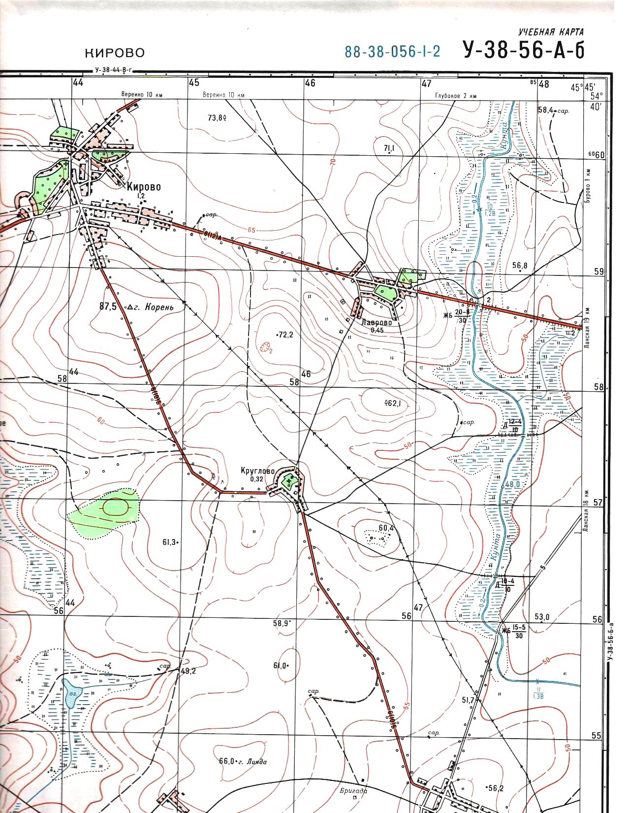
1. How many inhabitants live in us. point Kruglovo sq.?
2. On which bank of the Kunta river is we located. point Lavrovo sq. .?
3. What does the signature near the river Kunta D 12-104 square mean?
Selected document to view keys 7 cl..docx
Library
materials
Requirements for holding the municipal stage of the Olympiad in the subject:Geography
duration of tasks,
1.5 hours are allotted to complete 2 rounds (2 academic hours)
Number of tours -2 (Test and Theoretical)
The possibility of using reference literature -the use of reference literature is not provided
Electronic computing and communication facilities - the use of computing facilities and communication facilities is not provided
The list of necessary equipment for the Olympiad (if necessary) - pen, ruler, pencil.
Criteria and methodology for checking solutions to problems: the assessment of the answers of the participants in the municipal stage of the Olympiad is determined on a multi-point scale. For the tasks of the test round, one correct answer is equal to 1 point, for the tasks of the theoretical round, the maximum possible number of points for a completely correct answer, written in the key to in the key to assessment, is determined.
Answers
Test tasks:
1 – c, 2 – d, 3 – d, 4 – d, 5 – b, 6 – d, 7 – b, 8 – b, 9 – d, 10 – c, 11 – d, 12 – c, 13 – d, 14 – a, 15 – c, 16 – c, 17 – b, 18 – d, 19 – a, 20 – a.
Theoretical tasks.
Exercise 1.
Greenland, New Guinea, Kalimantan, Madagascar, Baffin Island, Sumata, UK, Honshu. The coldest is Greenland, as it is located in the Arctic. The warmest is Kalimantan, as it is crossed by the equator.
Task 2.
There are 4 poles in the northern hemisphere. 1) - the geographic North Pole, this is the point through which the imaginary axis of the Earth passes; 2) - northern magnetic pole, it is currently found in North America north of the Canadian Arctic Archipelago.It should be noted that from a physical point of view, this pole is "south", since it attracts the north pole of the compass needle; 3) - pole of relative inaccessibility, point with coordinates 83 0 50 / NL and 170 0 o.d. the area is very difficult to get into; 4) - the pole of cold, Oymyakon, where the temperature was -71 0 WITH.
Task 3.
Snow is small ice crystals (therefore it is cold, the temperature is below zero degrees Celsius), combined into loose snowflakes (therefore, there are air cavities in the snow cover, and air is a poor conductor of heat, therefore the ground under the snow does not freeze, snow does not give heat to escape from the ground).
The greater the snow cover, the more water it will give to the soil in spring, and therefore the crops will develop in better conditions.
Strong heat leads to a decrease in atmospheric pressure (warm air rises), therefore, there is a difference in atmospheric pressure with a neighboring territory, and a difference in atmospheric pressure in neighboring territories leads to wind. Coolness is a decrease in temperature, a significant weakening of the heat. As a result, conditions are created for the condensation of water vapor.
Task 4.
This is the extreme southwestern point of Africa. Bartolomeu Dias reached it during a terrible storm and therefore called the Cape of Storms. The king saw this as a good sign of the opening of the sea route to India and Indochina, which drained large profits. The sea route to India was discovered by Vasco da Gama in 1497-1499.
Task 5.
1. On the right bank.
2. 320 inhabitants
3. Wooden bridge 12 m long, carriageway width 4 m, load capacity of the bridge 10 tons.
Key to evaluation.
Test tasks
Theoretical tasks
Exercise 1 .
For each correctly named island - 1 point, the name of the warmest and coldest island - 1 point each. Indication of reasons - 1 point for each island. The total amount is 12 points.
Task 2 .
The correct name of the poles - 1 point for each, the full description of the pole - 2 points for each. The total amount is 9 points.
Task 3 .
A complete and correct answer with an explanation of the causes and consequences of 5 points for each sign. Correct, but not complete answer, without explanation - 2 points for each sign. The total amount (max) - 15 points.
Task 4.
The geographical position of the cape - 1 point. Explanations of differences in the name - 2 points each. The discoverer of the sea route - 1 point, the years of discovery - 2 points. The total amount is 8 points.
Task 5.
1. Right bank - 3 points.
2. Number of inhabitants - 3 points
3. Wooden bridge 12 m long, carriageway width 4 m, bridge carrying capacity 10 tons (for each correct item 2 points). The maximum is 6 points.
Total amount - 12 points
The total score for the theoretical round is 56 points.
The total amount for two rounds is 76 points
Selected document to view Tasks of the municipal stage Grade 8.docx
Library
materials
Tasks for the municipal stage of the Olympiad Grade 8
Test tasks
Name the climatic zone indicating the hemisphere, which is characterized by the following features: _____________________________________________________________
Average July temperatures are around +16°С - +20;
Average January about -8 - -24°С;
Precipitation falls mainly during the warm period;
The annual amount of precipitation is 500-600 mm
If at the level of the Kara Sea the temperature is +8°C, then what is the temperature of the air (containing water vapor) at the top of Mount Narodnaya (1895 m)? ______
At what parallel is the polar day observed on June 22:
1) 80 NL 2) 45 NL 3) 45 S 4) 80 S
Arrange the mountains in order of increasing absolute height. Write your answer as a sequence of numbers. 1) Aconcagua, 2) Belukha, 3) Elbrus, 4) McKinley.
Isotherms - lines on maps connecting points with the same values ... (1 point)
1. surface air temperature
2. absolute height
3. relative height
4. depths of the bottom of the reservoir
6. The direction to the SE corresponds to the azimuth (1 point):
1. 55º
2. 135º
3. 225º
4. 315º
7. Choose the correct correspondence "natural zone - soil": (1 point)
1. mixed forests - chestnut soils
2. taiga - red-yellow ferralitic soils
3. broad-leaved forests - gley soils
4. steppe - chernozems
8. Stable areas of the earth's crust are called:
platforms;
folded belts;
plains;
hills.
9. With what symbol can you determine on the terrain plan a hill or a depression?
horizontal.
punch.
berghash.
isochrone.
10. What is the largest lake in the world by area?
Lake Baikal
Ladoga lake
Caspian Sea
Lake Titicaca
11. From which sea is it impossible to land?
North Sea
Sargasso Sea
caribbean sea
Arabian Sea
12. In which of the following regions of Russia are earthquakes often observed?
Kamchatka
Altai
Central Siberian Plateau
13. What are the most fertile soils called?
1) black soil
2) podzolic
3) tundra-gley
4) brown
14. In which part of the oceans are the most living organisms:
1) on the continental slope
2) offshore
3) on the bed of the ocean
4) in gutters
15. On which continent of the Earth is the share of protected areas the highest?
1) Africa
2) Eurasia
3) Australia
4) America
Theoretical tasks
Tasks 1.
"The most-most on the planet":
1. What continent is it on. The highest point on the Earth and its name, height _______________________________
2. What continent is it on. The lowest point on the Earth and its name, height ________________________________
3. What continent is it on. The highest waterfall in the world and its name, the height of the water fall
_____________________________
4. What continent is it on. The highest volcano and its name, height
___________________________________
Task 2.
Lake Issyk-Kul in translation into Russian means "warm lake". In fact, the water in the lake is very cold. Where is this lake located? Why is it called "warm"?
Task 3.
Use the map below to answer the following questions:
1. Determine the excess between the point of the state geodetic network of the city of Root, sq. and the river Kunta sq.
2. On the slope of what exposition does the improved highway pass from the eastern outskirts of Lavrovo to the bridge over the river Kunta kv.?
Selected document to view Answers Grade 8.docx
Library
materials
Requirements for holding the municipal stage of the Olympiad in the subject:Geography
duration of tasks,
1.5 hours are allotted to complete 2 rounds (2 academic hours)
Number of tours -2 (Test and Theoretical)
The possibility of using reference literature - the use of reference literature is not provided
Electronic computing and communication facilities - a calculator, the use of communication facilities is not provided.
The list of necessary equipment for the Olympiad (if necessary) - pen, ruler, pencil.
Criteria and methodology for checking solutions to problems: the assessment of the answers of the participants in the municipal stage of the Olympiad is determined on a multi-point scale. For tasks of the test round, one correct answer is equal to 1 point, for tasks of the theoretical round, the maximum possible number of points for a completely correct answer, written in the key to the tasks, is determined.
Answers
Test tasks
1) temperate zone; 2) -2.8 ºС; 3) 1; 4) 2,3,4,1; 5) 1; 6) 2; 7) 4; 8) 1; 9) 3; 10) 3; 11) 2; 12) 1.; 13) 1; 14) 4; 15) 1.
Theoretical tasks
Exercise 1.
"The most-most on the planet":
Eurasia, Everest, 8848m.
Eurasia, Depression Ghor (Elgor), - 395m.
South America, Angel, 979m.
Africa, Kilimanjaro, 5895 m.
Task 2.
Lake Issyk-Kul is located at 42 degrees north latitude, in the Tien Shan mountains, between high mountain ranges. The water in it never freezes. The lake is very deep (over 700 m), the masses of water heated during the summer do not have time to cool. In addition, the water in the lake is brackish, and strong winds promote constant mixing, which prevents it from freezing.
Task 3.
1. -39.5 m (for the absence of a minus sign (-50%).
2. Along the slope of the eastern exposure.
Key to evaluation.
Test tasks
1 task - 1 point. The total amount is 15 points.
Theoretical tasks
Exercise 1 .
For each correctly named continent - 1 point, the name of the object - 1 point. Indication of height - 2 points each. The total amount is 16 points.
Task 2 .
Correctly named location of the lake - 5 points. Explanation of the name (latitude of the place, intermountain basin, depth of the lake, salinity of water, mixing processes) - 10 points (2 points for each reason). The total amount is 15 points.
Task 3 .
1. -39.5 m., - 4 points, in the absence of a minus sign - 2 points
2. On the slope of the eastern exposure - 2 points
The total amount is 6 points.
The total amount is 52 points.
Selected document to view Tasks of the municipal stage Grade 9.docx
Library
materials
Tasks for the municipal stage of the Olympiad Grade 9.
Test tasks
1. Select the river on the banks of which the capital of the republic whose inhabitants profess Buddhism is located:
1. Argun;
2. Cupid;
3. Selenga;
4. Don.
2. Which of these entities does not produce coal:
1. Krasnoyarsk Territory;
2. Krasnodar Territory;
3. Kemerovo region;
4. Irkutsk region.
3. Which of the subjects of the Russian Federation is not included in the KMA region:
1. Kursk region;
2. Belgorod region;
3. Bryansk region;
4. Oryol region.
4. Which of the following millionaire cities stands on the river, the medieval name of which is ITIL:
1. Samara;
2. Ufa;
3. Perm;
4. Novosibirsk.
5. Which mineral is being mined at these deposits: Nezhdaninskoye, Natalka; bouldery:
1. Copper;
2. Tin;
3. Zinc;
4. Gold.
6. Which of the following nuclear power plants is located outside of Russia:
1. Bilibinskaya;
2. Ignalina;
3. Balakovskaya;
4. Beloyarskaya.
7. Which of the listed peoples do not live in Dagestan:
1. Avars;
2.Tabasarans;
3. Nogais;
4. Kumandins.
8. Under the leadership of which of the following scientists was prepared and carried out the First General Census of the Population of Russia:
1. Arseniev K.I.;
2. Baransky N.N.
3. Semyonov P.P.;
4. Semyonov V.P.
9. The age and sex structure of the population of Russia is characterized by the predominance of the number of men over the number of women:
1. in the middle and older age groups;
2. in the younger and older age groups;
3. none of their age groups;
4. only in junior.
10. Which of the republics is not part of the North Caucasian Federal District:
1. Ingushetia;
2. Udmurtia;
3. Kabardino-Balkaria;
4. Adygea.
11. What is the share of the indigenous people in the ethnic structure of Tatarstan according to the results of the 2010 census:
1. 27 %;
2. 53 %;
3. 84 %;
4. 48 %.
12. Select an island that is not part of Russia from the list:
1. o. Wrangel;
2. Father Rudolf;
3. o. Svalbard;
4. o. Schmidt.
13. Which of the following subjects of the Russian Federation has the highest population density:
1. Republic of Buryatia;
2. Republic of Bashkortostan;
3. Udmurt Republic;
4. Republic of Adygea.
14. In the basin of which river is irrigated agriculture not widespread;
1. Kuban;
2. Don
3. Vychegda;
4. Ob.
15. What subjects of the Russian Federation does not border the Chechen Republic:
1. North Ossetia - Alania;
2. Stavropol region;
3. Kabardino-Balkaria;
4. Dagestan.
16. Which center of traditional folk crafts specializes in the production of lace products:
1. Gzhel;
2. Palekh;
3. Mtsensk;
4. Fedoskino.
17. Which islands are uninhabited:
1. Commander:
2. New Earth;
3. Severnaya Zemlya;
4. Solovetsky.
18. Select seaports that do not belong to the Arctic Ocean basin:
1. Tiksi;
2. Pevek;
3. Anadyr;
4. Eastern.
19. The main area of residence of which people does not have access to the sea:
1. Kumyks;
2. Nenets;
3. Mari;
4. Chukchi.
20. Choose from the proposed regions the region with the lowest forest cover of the territory:
1. Kostroma region;
2. Kursk region;
3. Astrakhan region;
4. Belgorod region
Theoretical tasks
Exercise 1.
Which mineral deposits are referred to in the text? On the territory of which subject of the Russian Federation is it located and what is the name? Name the cities where mining sites are located.
Mining sites are characterized bycontinentalwith frequent and sharp fluctuations in air temperature, precipitation and solar radiation intensity. The discoverer is D. G. Messerschmidt, who discovered the deposit in 1721 and named it "Fire-breathing Mountain". The territory is characterized by almost universal anthropogenic transformations of natural landscapes and subsoil - from relatively small changes caused mainly by forestry activities in the eastern part, to almost complete transformation during mining and urbanization in the western part of the territory. Extraction by open pit and mine method. Development problems are associated with an unfavorable geographical position, remoteness from the main consumer areas. The mineral is difficult to transport due to the poor development of railway networks. Large transportation costs reduce the competitiveness of minerals in the market.
Task 2.
Match the old and new names of historical cities listed in the list:
New name
Former name
Makhachkala
Voroshilovsk
Elista
Novokholmogory
Syktyvkar
Port-Petrovsk
Stavropol
Shcheglovsk
Arkhangelsk
Obdorsk
Kemerovo
steppe
Salekhard
Ust-Sysolsk
What is the old name of the cities:
New name
Former name
Ulan-Ude
Vladikavkaz
Izhevsk
Permian
Pskov
Orenburg
Novosibirsk
Task 3.
The table shows the contribution of the Federal Districts of Russia to the sown area of agricultural crops in 2013. Analyze the table and determine which crops are denoted by the letters A, B and C. Explain your answers in each case.
federal district
A
B
IN
100,0
100,0
100,0
Central Federal District
55,2
32,1
Northwestern Federal District
0,6
-
11,1
Southern Federal District
17,1
15,6
1,3
North Caucasian Federal District
6,5
4,2
-
Volga Federal District
28,7
22,9
21,9
Ural federal district
-
1,1
Siberian Federal District
1,9
32,6
Far Eastern Federal District
-
-
Letter designation
Agriculture
Explanations
A
B
IN
Task 4.
When were these coats of arms approved? What features of urban development characterize the images? How was the "fate" of these cities, what is their current status?
Task 5.
Use the map below to answer the following questions:
1. Determine the geographical coordinates (latitude and longitude) of Linda, sq. .
2. At what distance from the equator (in km.) is the settlement Kruglovo sq.?.
3. Is it possible from the top of Linda sq. through marine binoculars with a multiple increase to see the dome of the church (whose height is 20 meters) in the village. Kirovo sq.? Explain your answer.
Selected document to view keys 9 cl..docx
Library
materials
Requirements for holding the municipal stage of the Olympiad in the subject:Geography
duration of tasks,
1.5 hours are allotted to complete 2 rounds (2 academic hours)
Number of tours -2 (Test and Theoretical)
The possibility of using reference literature - the use of reference literature is not provided
Electronic computing and communication facilities - the use of a calculator is possible, the use of communication facilities is not provided.
The list of necessary equipment for the Olympiad (if necessary) - pen, ruler, pencil.
Criteria and methodology for checking solutions to problems: the assessment of the answers of the participants in the municipal stage of the Olympiad is determined on a multi-point scale. For the tasks of the test round, one correct answer is equal to 1 point, for the tasks of the theoretical round, the maximum possible number of points for a completely correct answer, prescribed in the key to assessment, is determined.
Answers
Test tasks
1 – 3; 2 – 2; 3 – 3; 4 – 1; 5 – 4; 6 – 2; 7 – 4; 8 – 3; 9 – 4; 10 – 2; 11 – 2; 12 – 3; 13 – 4; 14 – 3; 15 – 3; 16 – 3; 17 - 3; 18 – 4; 19 – 3; 20 – 3.
Theoretical tasks
Exercise 1.
Coal;
Kemerovo region, Kuzbass;
Kemerovo, Kiselevsk, Prokopyevsk, Anzhero-Sudzhensk, Osinniki, Leninsk-Kuznetsky, Novokuznetsk, Belovo, Berezovsky, Polysaevo, Mezhdurechensk
Task 2
New name
Former name
Makhachkala
Port-Petrovsk
Elista
steppe
Syktyvkar
Ust-Sysolsk
Stavropol
Voroshilovsk
Arkhangelsk
Novokholmogory
Kemerovo
Shcheglovsk
Salekhard
Obdorsk
New name
Former name
Ulan-Ude
Verkhneudinsk
Vladikavkaz
Ordzhonikidze
Izhevsk
Ustinov
Permian
Molotov
Pskov
Pleskov
Orenburg
Chkalov
Novosibirsk
Novonikolaevsk
Task 3.
A - cereals and legumes;
B - sugar beet;
B - fiber flax
Task 4.
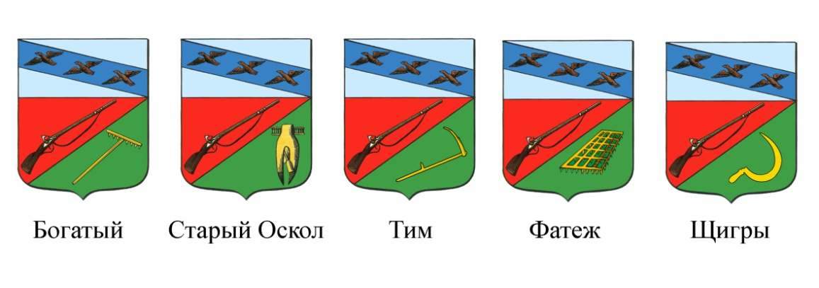
1780
In the upper part is the coat of arms of Kursk: in a silver field there is a blue stripe and on it are three flying partridges; in the lower part, divided in two, in one part in the red field of the gun, and in the other in the green field of the golden scythe, so that the inhabitants of it are ancient warriors practicing in their free time in arable farming, for which the coat of arms also has a military weapon with tools of careful cultivator connected.
Rich - villageV .
Task 5.
1. φ=54036′56′′ n.l. λ= 45042′12′′ E (+ - 5′′).
2. 6057 km.
3. No, because in this direction is the town of Root, with a mark of 87.5m, which does not allow you to see the domes of the church.
Key to evaluation.
Test tasks
1 task - 1 point. The total amount is 20 points.
Theoretical tasks
Exercise 1 .
Hard coal - 1 point;
Kemerovo region, Kuzbass - 2 points;
Any 8 cities listed - 4 points (maximum)
(Kemerovo, Kiselevsk, Prokopievsk, Anzhero-Sudzhensk, Osinniki, Leninsk-Kuznetsky, Novokuznetsk, Belovo, Berezovsky, Polysaevo, Mezhdurechensk)
Total amount: for a correctly identified object and answers to questions - 7 points.
Task 2.
For each correctly indicated match and the old name of the city, 1 point.The total score is 14 points.
Task 3.
total amount: for a correctly completed table - 8 points.
Task 4.
Answers:
1780 - 1 point
In the upper part is the coat of arms of Kursk: in a silver field there is a blue stripe and on it are three flying partridges; in the lower part, divided in two, in one part in the red field of the gun, and in the other in the green field of the golden scythe, so that the inhabitants of it are ancient warriors practicing in their free time in arable farming, for which the coat of arms also has a military weapon with tools of careful cultivator connected. For a correct and accurate answer - 2 points.
Rich - villageV .
Stary Oskol is a city in the Belgorod region;
Tim is an urban-type settlement in the Kursk region;
Fatezh and Shchigry are cities of the Kursk region.
2 points for a correct answer.
Total amount - 11 points
Task 5.
1. φ=54036′56′′ n.l. λ= 45042′12′′ E (+ - 5′′) correctly indicated coordinates 4 points.
2. 6057 km. – 4 points
3. No, because in this direction is the town of Root, with a mark of 87.5m, which does not allow you to see the domes of the church. - 2 points
The total amount is 10 points.
The total amount is 70 points.
general information
Olympiad assignments in geography for grade 6 (school level)
2015-2016
Tasks of the theoretical tour.
Each of you, of course, read V. Garshin's fairy tale "The Frog is a Traveler" and remembers how her unusual journey ended: there was a hard road, but much further, which was great happiness for her, because she flopped into a dirty pond at the edge of the village. Determine in which direction in relation to the village was the pond.
During a cycling trip, its participants move at an average speed of 12 km per hour. The distance between the start and finish of their route on the map is 6 cm, and the map scale is 1:1000000. Determine the time required for the tourists' bike trip.
On the map, determine which cities have geographical coordinates:
39N 116E -
19N.W.99W.L. -
34S.W.19E -
30N.W.31E.L. -
Name the city from the photo. (coordinates are given)
What environmental disturbances have been caused by economic activities in your country? locality? What environmental measures should be taken to eliminate the consequences of these violations?
Test tasks.
1. Choose a continent located in three hemispheres:
A) Africa
B) North America
B) Australia
D) Antarctica
2. Choose an incorrect statement:
Geography studies:
A) changes in the earth's topography
B) climate features
C) features of the distribution of the population
D) the frequency of lunar eclipses
3. The ancient Greeks put forward the idea of the sphericity of the Earth based on:
A) the existence of ebbs and flows
B) observing lunar eclipses
B) traveling around the world
D) space research
4. To determine the sides of the horizon, use the device:
A) weathervane
B) gnomon
B) compass
D) level
5. Parallel 0 0 does not cross the ocean:
B) Atlantic
B) the Arctic
D) Indian
6. Which lines converge at the pole point?
A) parallels
B) meridians
D) polar circles
D) air lines
7. Place the inner shells of the Earth in the correct order from the center to the surface:
A) the earth's crust
B) mantle
8. Match:
9. Make a match:
| River | ocean basin |
| B) Amazon B) Huang He D) Yenisei | 1) Indian Ocean 2) Pacific Ocean 3) Atlantic Ocean 4) Arctic Ocean |
10. What proportion of the earth's surface is occupied by the waters of the oceans?
11. The wind that changes its direction twice a day is called:
A) monsoon
B) trade wind
B) a breeze
12. A group of tourists went to the mountains. At the foot of the temperature was +24 0 C. What will be the temperature at a height of 3 km?
13. The biosphere is a shell of distribution:
A) animals
B) plants
B) a person
D) living organisms
14. Add:
A) The system of meridians and parallels on geographical maps and globes, which serves to count the geographical coordinates of points on the earth's surface, is called _____________________
B) Plains, the absolute heights of which exceed 500m, are called ______________________
C) The movement of air over the earth's surface in a horizontal direction is called _____________________________________________________________________________________
D) The water stream flowing in the depression he has developed is called _______________________
15. The most correct idea of the shape, size and relative position of geographical objects in a small area can be obtained using:
A) a map of the world
B) drawings by artists
B) plan of the area
D) photographs of local landscapes
16. Determine on the territory of which continent the point with coordinates is located
66 0 N, 180 0 Long
A) Eurasia
B) Africa
B) North America
D) Antarctica
17. Lines on the globe, parallel to each other, show:
A) the same depths of the ocean
B) longitude of the place
B) height on the ground
D) latitude
18. What layer is missing in the composition of the oceanic crust?
A) basalt
B) granite
B) sedimentary
19. Which part of the hydrosphere makes up the smallest share?
A) underground water
B) swamps
20. Which of the seas is marginal?
Baltic
Barents
Answer keys for grade 6.
Theoretical tasks:
1. Ducks flew south. The frog also traveled with them. Falling, she continued to move south by inertia and fell into a pond, which was located south of the village. -4b
2. 5 hours.- 4b.
3.Beijing; Mexico City; Cairo; Cape Town - 6b. Pictured is the city of Cairo.
4. The formation of ravines, the reduction of forest area, the shallowing of rivers, the disappearance of animal and plant species. Measures - the correct plowing of fields, the prohibition of poaching, the restoration of forests along the banks of rivers, protection from fires. 6b.
Test tasks: - 20b.
14-a-grid; b- plateau; in - wind; g - river.
Sum of points: - 40 b.
Olympiad tasks in geography for grade 7 (school level)
2015-2016
Tasks of the theoretical stage.
No, I'm not a wolf or a fox!
You come to us in the woods,
And there you will see a dog -
Warrior Dingo!
The forests of what continent invites you to visit the author of the poem "The Dingo Dog" S.Ya.Marshak? Do you have doubts about such an invitation? Why?
The ship at the point with coordinates 30S. 70w.d. crashed, the radio operator transmitted the coordinates of his ship and asked for help. Two ships "Nadezhda" (30S 110E) and "Vera" (20S 50E) headed for the disaster area. Which ship will come faster to the aid of a sinking ship?
Build a graph of the growth of the population of the Earth according to the table.
Population Growth
| 0 AD | |||||
| Population, million people |
On the territory of our region there is an active construction of economic objects. What environmental violations can be caused by the construction of a highway, a cosmodrome, a gas processing plant?
Test tasks.
1. The highest mountain system in the world.
Appalachians
2. Volcano in Southeast Asia.
Cotopaxi
kilimanjaro
Klyuchevskaya Sopka
Krakatoa
3. Area of distribution of geysers.
Island New Zealand
Arabian Peninsula
Appalachians
4. A plain located in the western hemisphere.
West Siberian
Great Chinese
Amazonian
Eastern European
5. The widest strait in the oceans.
Malay
Magellan
Beringov
6. Islands belonging to the group of coral islands.
Hawaiian
Madagascar
Greenland
Great Barrier Reef
7. The sea, washing the shores of only one mainland.
mediterranean
caribbean
Okhotsk
8. The main reasons for the change of seasons
The tilt of the earth's axis and the rotation of the earth around the sun
Rotation of the Earth around the Sun
Rotation of the Earth around its axis
Tilt of the earth's axis
9. The sun evenly illuminates both hemispheres of the Earth
December 22
23 September
10. The guys walked 200 m north, then walked 300 m along the azimuth 270 o, after which they turned south and walked another 400 m. In what direction is the end point of the route from the beginning of the route?
In the north-east
In North-west
in the southeast
In the South-West
11. On what continent is the point with coordinates 10 o S, 60 o W?
Australia
South America
North America
12. The length of each of the meridians is
13. The country is located in an earthquake-prone region of the world.
Australia
Finland
14. A city that didn't have a catastrophic earthquake.
San Francisco
15. Area of active volcanic activity.
Madagascar island
Central Siberian Plateau
Scandinavian Peninsula
G. Kamchatka Peninsula
16. Which of the seas is marginal?
Baltic
Barents
17. Which concept is superfluous in the series of the following:
Estuary
18. 2. What natural area is not found in Russia?
Deserts and semi-deserts
Forest-steppes and steppes
Savannahs and woodlands
19. Soils characteristic of savannahs and light forests
Podzolic
gray forest
Chernozems
Red and brown red
20. The most fertile soil.
gray forest
brown forest
chestnut
Chernozem
Answer keys for grade 7.
Theoretical tasks:
1. We are talking about Australia. However, dingoes are not permanently inhabited by forests, but by savannahs and dry steppes around Lake Eyre. - 6b.
2. The ship "Vera" will come to the rescue first. -4b.
4. Deforestation, damage to the soil layer, reduction in the number of animals and plants, air and water pollution, disturbance of river nutrition, etc. - 6b.
Test tasks: - 20b.
Sum of points: -40b.
Compiled by Petrenko L.I. - Geography teacher, Nizhnebuzulinskaya secondary school