Engineering and geological surveys for construction. What is included in engineering and geological surveys for construction? Geological work for construction
Geological surveys give us the opportunity to technically substantiate the feasibility, as well as the principle of the feasibility of construction in a particular area already at the design stage. In case there is a need for a preliminary assessment of the feasibility of building in the selected area from an economic point of view, engineering and geological surveys become a mandatory preparation procedure before construction begins.
The features of the relief, the hydrological regime of the area of the selected development are determined using geological surveys. The mechanical composition of soil and soil is also studied. With the help of the data acquired in the process, the tectonic and seismological characteristics of the area are compiled. Here, a forecast of possible changes in the geomorphological, hydrological situation is also made, which can change after and during the construction of the facility. A comprehensive engineering and geological study of the territory of a new building is of paramount importance in the design of a building. All this is carried out directly at the stages of pre-initial preparation.
Geotechnical surveys are used to calculate the reliability of the area allocated for construction. Naturally, this is carried out before the start of designing the foundation of a new facility. The choice of the type of building foundation and the subsequent design are made on the basis of information about the physical and chemical qualities of the soil and the hydrological regime of the given territory (in particular, information about the levels of groundwater). In case of lack or absence of such information from geological surveys, the probability of errors and shortcomings of engineers increases during the design of the project. Incorrect design of the foundation over time can turn into deformation, premature destruction of the constructed object.
The construction of a new object in the city often occurs next to an existing building or development. Such construction can lead to modifications of the geomorphological process in neighboring territories, which can lead to deformation of already constructed buildings. The situation is further aggravated by the fact that the underground section of the new building is often used to create shopping arcades or parking lots for cars. The reconstruction of an existing building is very often associated with an increase in the load on the foundation of the building. This feature of development in the city requires a special, thorough study of the places of planned construction and the selection of a territory that meets all the necessary safety requirements.
Geological surveys have absorbed many areas of research:
- assessment of archival information of similar studies in the territory of the planned construction (provided that such information is available);
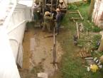
- drilling of a geological well;
- selection of soil and water samples for research in the laboratory. Study of the chemical, as well as physical and mechanical properties of the material;
- geophysical study in order to detect a territory with an unfavorable geological composition, identification of underground utilities, routes and other objects;
- study of the geological structure of a given piece of land allocated for future construction;
- study of the hydrological regime, as well as the structure of groundwater and soil features in the study area;
- detection of actual and potentially acceptable processes that pose a danger to the construction of the building, its subsequent operation;
- geodetic reference of planned objects, as well as parallel engineering developments on the ground.
Geological surveys provide a chance obtain information on the basis of which a technical report is created. This report is subject to approval by Mosgorgeotrest and Mosoblgeotrest.
 The study of materials from the archive on the geological survey on the site of the planned construction. The availability of information about the previously carried out study of the territory of the planned building provides the opportunity for the most accurate display of the current geological process. Information about the dynamics of changes in the geological structure of the territory and its hydrological regime is essential for predicting further changes in geoactivity, taking into account the impact of the future object on the geoenvironment. Drilling of a geological well, samples and laboratory analyzes of the material. Well drilling is carried out in order to take soil samples at various depths for subsequent laboratory analysis. The laboratories conduct studies of the physical and chemical properties of the soil, in particular, its exchange and absorption properties, the tendency to shrink, swell, osmosis, diffusion, as well as corrosiveness and some other qualities.
Geophysical work to detect a geologically unfavorable area, underground communication and other underground object can be carried out by examining data from the archive, as well as using the instrumental method. Study of the hydrological regime of the territory, the composition of underground groundwater and the characteristics of the soil, soil.
The purpose of the study is to study the changes in the water body located on the territory of the future construction. What is the impact of anthropogenic and natural factors on water bodies. In the process of research, the dynamics of possible modifications of water is known - the channel, level, composition, temperature.
Study of the geological structures of the area, in which construction work will be carried out, includes a complex for soil analysis in order to obtain information about the chemical composition of the soil, as well as determine its geotectonic platform. Information about the peculiarities of the geological structure of the territory, as well as information about the hydrological regime, is used to form the results of a destructive process that complicates the construction of a building and poses a danger to its operation. The results, in turn, serve as a basis for anticipating subsequent developments of a possible and identified occurrence that was not previously seen in the geological process. Geodetic attachment of the object, as well as the accompanying engineering development to the territory, is necessary for the highest accuracy of geodetic surveys. Of course, that this is relative to the stronghold in the territory.
 Study of the geological structure of the area in which construction work will be carried out includes a comprehensive analysis of soil and soil to obtain data on the chemical composition of the soil and determine the geotectonic platform. The obtained data on the features of the geological structure of the site and the existing hydrological regime are used to generate statistics of destructive processes that impede the construction of the facility and pose a potential danger to its operation. Statistics, in turn, serves as the basis for predicting the further development of identified and the possible occurrence of previously unrecorded geological processes.
Physical and chemical characteristics of the soil is entered in a table, which, like the topographic plan, is added to the technical report on the geological work done. Reports are built on the basis of regulatory documents that regulate the scope of work. Further, the reports are subject to coordination in the state institution Mosgorgeotrest and Mosoblgeotrest. To carry out geological surveys in the conditions of preparation (pre-project) of future construction, the customer organizes the terms of reference. This task is drawn up in accordance with the requirement of clause 4.13 of SNiP 11-02, as well as the topographic plan of the territory allotted for construction with marked underground communications and the outline of the planned building. If these documents are available, a program of geological surveys is formed. And the very complex of studying the territory for the construction of a new facility is carried out on the basis of this program.
We provide services in the following districts of the Moscow region
The services of our company include carrying out engineering and geological surveys for construction in Moscow and the Moscow region. Studies are necessary to assess the features of a potential construction site when making decisions on the feasibility of work, choosing the type of foundation and building materials. In addition, based on the data obtained, it is possible to calculate the final cost of the project and its economic efficiency. At the same time, the composition of surveys for construction should correspond to the characteristics of the region where development is planned, and provide complete information on the soils on the land plot.
Terms of reference and terms of research
Before starting the research, it is necessary to prepare the terms of reference for engineering and geological surveys. The document should include data on the characteristics of the object, the depth of the wells and the distance between them, the timing of the geology for construction. As a rule, the preparation of the TOR is undertaken by the customer. But if necessary, our specialists are always ready to help.
The timing of geological surveys by GeoEcoStroyAnalysis is 1-2 weeks and depends on the characteristics of the soil. The exact duration of the work can be called after a visual inspection of the object.
The cost of engineering and geological surveys for construction
The calculation of prices for work is always agreed with the customer and is based on the criteria of the TOR, the number of linear meters, the location of the object and the complexity of the geological conditions. Due to the work carried out by responsible geologists using modern equipment, the clients of our company are provided with a set of reliable information.
The price for engineering and geological surveys from the GeoEcoStroyAnalysis company for construction in Moscow and the Moscow Region is 1300 - 2000 rubles. per linear meter and corresponds to:
- The timing of the work.
- The sizes of the studied objects.
- Features of the area where surveys for construction are carried out.
Note! Before performing geological surveys, the cost is fixed in the contract and remains unchanged throughout the cooperation.


Geological engineering survey program
Research tasks include:
- Familiarization with the features of the territory;
- Conducting reconnaissance;
- Studying the data of geological surveys of the land plot in the archives;
- Study of soil properties.
If it is planned to evaluate a site for the foundation of a house or industrial structure, the program of geological engineering studies begins with a reconnaissance and familiarization with the materials of previous studies with the current expiration dates.
Preparation
A qualitative geological study of the site cannot be carried out without careful preparation. It is thanks to the company's modern equipment for geodetic, environmental, geological and other types of surveys that it is possible to determine in advance the company's capabilities and stages of work, and calculate the distance between wells. The cost of engineering and geological surveys for construction at GeoEcoStroyAnalysis remains below the market and affordable for customers, because services are provided without the involvement of third-party contractors.
Drilling geological wells as part of surveys
Geological survey of the site within the framework of the field stage is impossible without drilling. Thanks to these works, as well as competent calculation, it becomes possible to get acquainted with all layers of soils. If you plan to order a service for the subsequent design of a house or any other object, well drilling is indispensable. In this case, the distance between them can be determined on the basis of standards. It is also worth noting that in cases where geological surveys for construction require special accuracy, topographic surveys are additionally performed.
Soil testing
On the eve of the design of linear or areal structures, it is necessary to order engineering and geological studies for construction, since it is impossible to do without comprehensive soil testing, which consists in sounding the soil and contributing to the preparation of a work plan. The tasks of performing tests and methods of engineering geological surveys are agreed with the customer in order to obtain reliable information on soils.
Laboratory research within the framework of engineering and geological surveys
The most important component of soil analysis is the study of soil properties in the laboratory using modern equipment. The data from the performance of geological surveys of wells form the basis of the technical report and become the basis for the designers of any facility. The GeoEcoStroyAnalysis company has its own soil laboratory, which is important for providing quality survey services. Moreover, its availability allows us to maintain optimal prices for all tests.
Composition of the report and the period of validity of geological surveys
Geodetic surveys involve the study of the relief of the site, the landscape of the area, the object itself, ground and underground communications, as well as soil, watercourses. The data and results obtained in the course of the work make it possible to assess the biological, sanitary and epidemiological safety, as well as soil layers and foundations.
The company "GEODRILLING" specializes in engineering and geological surveys. We provide our services to legal entities and individuals, guaranteeing the high quality of work and providing comprehensive assistance to customers. By contacting us, you can relieve yourself of responsibility for conducting surveys and preparing technical documentation.
Features of geodetic surveys
In the process of engineering and geodetic surveys, a complex of works is carried out. The area, adjacent areas are assessed, geodetic survey is carried out, the load on the soil, ground is calculated, wells are drilled. It is necessary to identify possible hazards for erected and future buildings. The soil and the factors influencing it, such as mudflows, landslides, seismic movements, and flooding, are studied. Mathematical modeling is carried out, thanks to which it is possible to make predictions regarding soil deformation, possible soil settlement.
As a rule, for carrying out all field work and reporting, it takes from 4 weeks. The quality of the conducted surveys is extremely important, since the safety of the operation of existing buildings and future facilities, as well as, in general, the presence of people in a given area depends on this. That is why we recommend that you contact only well-known companies - those with an impeccable reputation and extensive experience. In particular, in GEODRILLING LLC.
Official documents
Engineering and geodetic surveys are carried out taking into account the requirements of regulatory documents. The key one is SNiP 11-02-96. It is he who regulates the validity period of the survey results (it is 3 years), as well as the procedure for displaying amendments and data in technical reports.
After the expiration of the results of engineering and geodetic surveys, a recheck of the data is required, updating the information specified in the technical documentation. If capital work has not been carried out, as a rule, a small number of edits need to be made. If we estimate the total volume, then it is about 4-10%.
Terms of Reference
Our company conducts geodetic surveys based on the received technical specifications. Sometimes customers experience difficulties with its compilation. Therefore, in some cases, the terms of reference are formed with the participation of our specialists.
The terms of reference should indicate all the key tasks of engineering and geodetic surveys. It is necessary to attach the documentation that the customer has. These are standards, topographic maps, general schemes, cartograms, etc.
The TOR states:
- the main goals of geodetic surveys;
- types of surveys carried out;
- information about the object: address, number of buildings, etc.;
- available data obtained in the course of previous geodetic works;
- construction works: what is being built, what structure is being reconstructed, where expansion is planned, etc.;
- general parameters of buildings: the degree of responsibility of the structure, dimensions, area, type of foundation, etc.;
- details: the number of load-bearing structures, their location, the number of floors, basements (and their location), etc.;
- interaction with the environment: are there any harmful emissions, effluents, etc.
If you already have a technical specification, you just need to send it to us by e-mail. We will promptly consider your application and contact you to agree on the terms, cost of work and other nuances. Applications by e-mail are accepted around the clock.
Stages of work

As part of geodetic surveys, it is customary to distinguish 4 stages:
- obtaining technical specifications from the customer;
- field work;
- laboratory works;
- chamber stage.
We have provided information about the terms of reference above. All work is carried out by the specialists of GEODRILLING LLC on the basis of the TOR, and it cannot be otherwise.
As for field work, there are a number of tasks to be solved. To begin with, specialists receive the required number of soil samples, take groundwater samples. This can be done using wells or pits. Pit holes are formed by digging. Drilling technology is used to create wells. To ensure that the obtained samples do not deteriorate during transportation and storage, all samples are placed in special sealed flasks. In such containers, the natural properties and characteristics of the soil and groundwater are preserved, and their pollution is excluded.
Since we have our own laboratory, there are no difficulties with laboratory research. This is the second stage of work. A complete and in-depth analysis of the samples is carried out: it is necessary to obtain data on the chemical composition, physical properties, etc. Based on the results of the laboratory work, a report is drawn up. It describes the samples themselves, presents ready-made tables with data, charts and other graphic information based on the results.
The cameral stage involves the formation of a technical (final) report. Specialists evaluate the initial (previous) and obtained data, describe the features of engineering and geological surveys, soil types, site parameters, give the object a characteristic. Next, the data obtained from the laboratory is analyzed. A final report is compiled based on the results of the research, and general conclusions are drawn. In conclusion, the specialists of the company "GEODRILLING" give recommendations, taking into account the tasks that the customer himself has set for the engineers of our company. If we evaluate the time costs, then most of the time is required precisely at the cameral stage.
Formation of reports on the results of surveys
To draw up reports after a complex of geodetic works, established forms and samples are used. The customer receives a document containing:
- Title page.
- Contents of the technical report.
- Geological data.
- Physical-geographical introductory.
- hydrogeological conditions.
- Description of the studied soils.
- Description of the conducted engineering-geological surveys.
- Results of laboratory researches.
- Results and conclusions based on the results of the data obtained.
- Recommendations.
- Applications: graphics, illustrations, etc.
We are responsible for all developed reports and technical plans. All documentation complies with GOST and can be immediately sent to the supervisory authorities, used to obtain permits.
survey cost
The GEODRILLING company carries out an individual calculation of the cost of engineering and geodetic surveys due to the complexity and diversity of these works. We do not welcome turnkey packages, since in each case the list of activities may vary, in fact, as well as the scope of work. The price depends on the type of soil, the area of the land plot, the size of the foundation, the number of laboratory tests, soil sampling, the number of engineering and geological wells. Transport and labor costs are also taken into account. We can attract the right amount of equipment and specialists if tight deadlines are set for the work. Therefore, all conditions are negotiated with the client individually.
You can receive a personal offer from GEODRILLING LLC and take a break to consider it.
Advantages of the GEODRILLING company:
- a large staff of qualified and experienced professionals;
- high quality of rendered services and performed works;
- optimal cost of geodetic works: GEODRILLING performs all tasks on its own, thanks to which a transparent pricing policy is pursued;
- performance of geodetic surveys at any objects located in the Central Federal District of the Russian Federation;
- the presence of our own laboratory, which also reduces costs and duration of work;
- a large fleet of vehicles;
- cooperation with all legal entities and individuals;
- impeccable reputation created by years of successful work (we have been providing our services for more than 10 years).
If you have any questions, you need an accurate calculation of the cost of work, or you want to order services as part of geodetic surveys, please contact the experts of GEODRILLING LLC using a convenient communication method. We are ready to discuss your tasks and find the best solution!
Engineering and geological surveys – This whole group research definition-oriented geological And hydrogeological conditions on the site planned for the construction of a private house, an economic activity, linear highways, communication networks and other capital structures.
Complex of events presented not only field trials on the ground, but also by holding laboratory, cameral analyzes, making forecasts regarding the development of hazardous geological processes under the influence of natural and anthropogenic factors.
Our services
We are engaged in:
- conducting engineering and geological surveys of the soil at a professional level.
- we perform all types of engineering, geodetic and geological work in Moscow and nearby areas of the Moscow region,
- We work with both private developers and organizations.
- we will qualitatively and inexpensively carry out the geology of the site for the construction of the foundation of a private house or cottage, and give recommendations regarding further construction.
The cost of geological surveys depends on the scope of work, but in any case, our conditions are extremely favorable.
What determines the cost of research?
The cost of engineering and geological surveys is calculated on the basis of the Terms of Reference provided by the Customer. In rare cases, it may be necessary for a specialist to visit the facility to draw up an accurate estimate, taking into account the purpose of the research and the individual parameters of the site:
- size;
- number of storeys of the planned building;
- the degree of knowledge of the area;
- transport accessibility;
- design stage.
Also, the conditions for conducting, the time of year and the timing (how quickly the results are needed) are taken into account.
|
Building spot area |
1-storey building without basement |
2-storey building without basement, |
3 storey building without basement, |
|
Less than 15x15 m |
from 24,000 to 30,000 rubles (3 wells of 6 m each) |
from 28,000 to 35,000 rubles (3 wells of 8 m each) |
from 35,000 to 42,000 rubles (3 wells 10 m each) |
|
from 25 000 (2 to 8 m) |
from 25 000 (2 x 10 m) from 30 000 (2 by 12 m) from 40 000 (3m to 12m) |
||
|
More than 15x15 m |
from 28,000 to 35,000 rubles |
from 36,000 to 44,000 rubles |
from 42,000 to 50,000 rubles from 55 000 (4 x 12 m) |
What will happen if you do not do engineering and geological surveys before the construction of the facility?
A very popular opinion is that it is possible to build a house without carrying out the geology of the site. It is clear that developers are trying to save on this service, but only geological surveys of the area will help to decide on the possibility of building an object, allow you to accurately determine the type of foundation and the depth of its laying, and calculate the amount of building materials.
What are the consequences if the developer ignores the study of soils?
If the characteristics of the soil are not determined in the laboratory, then subsidence and deformation of the foundation during the operation of the building can lead to cracks in the foundation and walls, skewed windows and doors, flooding of the cellar and basement, which will require repair of the building, or cause its complete destruction.
If the calculation of the maximum load on the foundation and the maximum withstand pressure of the soil without deformation is not carried out, then the general settlement of the building structure, deviation from the vertical and the appearance of the effect of the Leaning Tower of Pisa are possible.
If the predicted level of groundwater occurrence is not determined, then dampness may soon penetrate the building, which will significantly accelerate the process of destruction of building materials, lead to the appearance of mold, which is dangerous for human health and life.
Qualitatively conducted research will ensure the reliability, functionality, stability, safety and durability of buildings, structures, linear objects, which will fully pay off the cost of research.
Terms of surveys
The speed of engineering and geological work depends on the scope of work. Timing is directly affected by:
- number of wells, 3 or more;
- the need for field testing of the soil with a probe, stamp;
- volume of laboratory research.
It is also necessary to take into account the purpose of the designed object. For the construction of industrial complexes, additional studies are required, in particular, environmental ones. In addition, the Technical Report for such structures is undergoing an examination, which increases the time for preparing materials.
On average, for cottage construction, the period for performing geological surveys from the moment of departure to the site until the issuance of a report does not exceed 10 calendar days. For industrial facilities, it can be up to 25 calendar days.
Survey result and report
The final report on the conduct of engineering and geological work is prepared in strict accordance with current requirements, contains data on the construction site, terrain features, the results of tests and studies.
The document includes:
- title page indicating the address of the study area, details of the contractor, the presence of a seal;
- an explanatory note describing the process, the methods used, the data obtained, the conclusions and recommendations drawn up;
- graphic materials in the form of a topographic plan of the site, drawings, tables, diagrams.
The technical report is submitted to the controlling federal and local authorities and is used to design the intended facility.
Example of a geological survey report
Purpose of geological work on the site
Engineering-geological surveys is a summarizing concept, the essence of which lies in conducting a study of the geological properties of the soil on the territory of the construction site. The main goal is to obtain all the necessary materials to fully justify the possibility of designing and building any facility in the selected area. Engineering-geological (survey) works include the following stages:
- Analysis of materials from early geological studies, if any;
- Research and study of the terrain;
- Carrying out drilling operations and taking samples and samples of soil and water;
- Comprehensive assessment of samples taken, testing of samples in the laboratory, determination of chemical, physical and mechanical properties;
- Engineering and hydrogeological surveys, study of the nature of groundwater;
- Assessment of the possibility of occurrence of adverse and dangerous natural phenomena: landslides, landslides, seismic activity, etc., making forecasts;
- Preparation of documentation and .
Geological surveys of soil
Full construction
Order
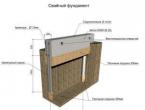
The primary task of engineering and geological surveys is to determine the properties of the soil to select the configuration of the foundation - the basis of the future structure. Depending on the strength indicators of the soil base, its corrosion activity, the depth of freezing, as well as the nature of groundwater and their chemical composition, the type and depth of the foundation, the need for additional protection and strengthening measures are determined. In addition, geological surveys are required:
- for the choice of building materials;
- to select the type of waterproofing;
- for the design of drainage and storm systems.
Integrated geological surveys for linear structures is a type of research characterized by increased complexity due to the significant length of structures. The work is not focused on a specific site, but along the route of the future structure.
Studies are necessary to study the geological, hydrogeological, climatic conditions on the highway, in particular, the determination of the bearing properties of the soil, the level of corrosive aggressiveness to metal and concrete structures.

Who needs?
Mandatory engineering and geological surveys are carried out in the case of the construction of public buildings, apartment buildings, utility facilities, linear routes. The technical report serves as the basis for the design and is attached to the documentation package sent to the regulatory authorities to obtain permission for construction.
The study of geological conditions is also a norm for owners of land plots for the construction of a house, a cottage. In particular, data on hazardous geological processes hidden from the naked eye are important: landslides, karsts, groundwater level rise. In addition, the top soil covers are mostly construction debris and household waste, which have non-uniform settlement rates, which leads to deformations and destruction of buildings.
Stages
Engineering and geological surveys include several stages, the implementation of which is prescribed by the SNiP standards. The scope of work includes:
- Preparation. Reconnaissance of the area, topographic research, study of archival materials on the site, determination of the scope of future work and the choice of methods.
- Field stage. Drilling, sounding and stamp testing of soils, description of the geological and lithological structure of the soil section, sampling of soil and groundwater samples.
- Laboratory stage. It is carried out in parallel with field work. In a certified chemical-soil laboratory, soil studies are carried out for physical and mechanical indicators: plasticity, fluidity, resistance to sediment, capillarity, the chemical composition and the degree of corrosion aggressiveness are determined.
- camera stage. Processing of the obtained data using computer programs and mathematical calculations, compiling a description of geological conditions, predicting possible changes and the risk of hazardous natural processes, drawing up a Technical Report.
ENGINEERING AND GEOLOGICAL SURVEYS FOR CONSTRUCTION
Engineering and geological surveys are an integral part of engineering surveys for construction, the procedure for which is regulated by SNiP 11-02-96 “Engineering surveys for construction. Basic Provisions".
Engineering and geological surveys are carried out in the design of various buildings, structures and their complexes. If necessary, they can be continued during the construction, operation, reconstruction and liquidation of facilities. The composition of engineering surveys, in addition to engineering and geological, includes other types of surveys:
Engineering and geodetic - obtaining topographic and geodetic materials, data on the terrain.
Engineering and hydrometeorological - climatic conditions, hydrological regime of rivers.
Engineering and environmental - assessment and forecast of the current ecological state.
In addition, engineering surveys for construction include the following special works:
- geotechnical control;
- survey of soils of the bases of the bases of buildings and constructions;
- local monitoring of environmental components;
- substantiation of measures for engineering protection of territories.
Engineering-geological surveys (IGS) - the production process of obtaining, accumulating and processing engineering-geological information to provide building design with initial data on the engineering-geological conditions of the area.
Engineering-geological conditions are a set of components of the geological environment that can affect the designed structures.
One of the most important tasks of engineering-geological surveys is the prediction of possible changes in the sphere of interaction between the designed structure and the geological environment.
The IGI includes the following main set of works:
- collection and analysis of available geological materials;
- decryption of space and aerial photographs;
- route observations, drilling and mining operations;
- geophysical surveys;
- experienced field work;
- stationary observations;
- laboratory research;
- Desk processing of the collected materials and preparation of a report.
The volume and content of the IGI in each case depends on:
- the degree of their knowledge;
- design stages (stages);
- the type (purpose) of the structure and the level of its responsibility.
The most significant volumes of drilling, experimental and other types of work are carried out during engineering and geological surveys for the construction of buildings and structures of an increased level of responsibility in difficult engineering and geological conditions.
The basis for the production of engineering and geological surveys is an agreement between the Customer and the Contractor of engineering and geological surveys. Mandatory appendices to the contract:
- technical task;
- calendar plan;
- estimate.
The terms of reference are drawn up by the Customer, it indicates:
- location of the proposed construction site;
- type of the designed structure;
- stage (stage) of design;
- design features of the designed structure;
- estimated loads on the foundation soils and other information.
The program of engineering-geological surveys establishes the composition, scope, methods and sequence of engineering-geological studies.
Performance of engineering-geological surveys without a program or prescription is not allowed. For their production, the Customer must obtain permission (registration) from the territorial executive authorities - the center for engineering surveys under the regional architecture. The basis for issuing a permit, in addition to the program, is a license, terms of reference and an estimate for the production of work.
Materials of engineering and geological surveys, transferred to the Customer in the form of a technical report, are subject to mandatory state expertise.
Engineering and geological surveys are carried out sequentially, in stages, in accordance with the design stages. The main stages of integrated research: reconnaissance, survey and reconnaissance. At the same time, the general principle of conducting geological work is maintained, when the area of research is reduced from stage to stage, but their detail increases.
Engineering-geological reconnaissance precedes the survey and is carried out for a preliminary assessment of the engineering-geological conditions of the construction area to substantiate pre-project documentation. Reconnaissance may not be carried out if there is a sufficient amount of archival materials.
The task of reconnaissance includes:
- preliminary identification of relief types and geomorphological elements;
- clarification of the collected geological materials;
- inspection and description of existing rock outcrops, groundwater outlets to the surface.
For this, route observations are carried out, and, if necessary, aero-visual observations, the excavation of shallow workings, and other work.
Based on the results of the reconnaissance, a schematic map of the engineering and geological conditions of the area is compiled.
An engineering-geological survey is carried out for areal assessment and mapping of the engineering-geological conditions of the area (site) of construction. The engineering-geological survey includes a full range of field, laboratory and cameral work.

Based on the data obtained during the survey, an engineering-geological map of the construction area is compiled, which makes it possible to identify areas most suitable for construction.
An engineering-geological map is information about the most important engineering-geological factors within the study area, it consists of the map itself, symbols, engineering-geological sections and an explanatory note.
Engineering-geological maps reflect the lithological composition and properties of rocks, their distribution, occurrence conditions, age and origin, information about groundwater and natural geological and engineering-geological processes.
To compile engineering-geological maps, various auxiliary maps are used: actual material, topographic, geological, geomorphological and building materials maps.
Engineering-geological maps are of three types:
- engineering-geological conditions;
- engineering-geological zoning;
- engineering-geological maps for special purposes.
The map of engineering-geological conditions contains information taking into account the satisfaction of all types of above-ground construction. It is used for a general assessment of the natural conditions of the area where construction will be carried out.
The map of engineering-geological zoning reflects the division of the territory into parts (regions, regions, districts, sites, etc.), depending on the generality of their engineering-geological conditions.

Special-purpose maps are drawn up in relation to specific types of construction or structures. They contain an assessment of the engineering and geological conditions of the construction site and a forecast of geological processes and phenomena.
Engineering-geological exploration is carried out at the final stage of the survey and serves to clarify the engineering-geological conditions under a separate building or structure. The basis for its production is the materials of engineering-geological survey.
As a result of engineering-geological exploration, the initial data necessary for the engineering-geological characteristics of soil foundations in the field of interaction of structures with the geological environment and for predicting changes in soil properties for the period of construction and operation should be obtained.
STAGES OF ENGINEERING AND GEOLOGICAL SURVEYS
Engineering and geological surveys for construction are carried out sequentially at various stages (stages).
There are the following main stages of work:
- pre-project (it includes pre-investment documentation, urban planning documentation and justification of investments in construction);
- design (the composition includes a project and working documentation for the construction of a structure).
Pre-project documentation is developed in order to justify the feasibility of building an object, the choice of construction sites and the direction of main transport and engineering communications, the basics of general schemes for engineering protection from hazardous geological processes, etc.
Engineering and geological surveys at the pre-design stages are carried out for large and complex objects. They should ensure the study of the main features of engineering-geological conditions of large areas and lengths of territories.
At all pre-project stages:
- pre-investment documentation;
- urban planning documentation;
- justification of investments in construction
Considerable attention is paid to the forecast for assessing the impact of construction projects on the geological environment.
When conducting engineering-geological surveys at the design stage, the list of surveys does not change, but the detail of their conduct increases.
Based on the results of the survey, a technical report is drawn up.
Engineering and geological surveys during the construction period are carried out only in special cases:
- during the construction of critical structures, especially in difficult engineering and geological conditions;
- in conditions of cramped urban development;
- with long breaks in time between the end of the survey and the start of the construction of the facility.
During the period of operation of the facilities, in necessary cases, in accordance with the instructions of the Customer, surveys of the soils of the foundations of the foundations of existing buildings and structures, as well as during their expansion, construction of new closely adjacent buildings, and in other cases.
Engineering and geological surveys for the reconstruction of buildings and structures are carried out, as a rule, in conditions of dense development and, therefore, should be carried out taking into account the specific natural and technical situation. A mandatory type of work is a full-scale survey of the surrounding area and the reconstructed building. During the survey, the geotechnical category of the object, the required scope of survey work, and the principal options for reconstruction and strengthening are established.
A small amount of engineering and geological surveys is carried out during the period of liquidation of buildings and structures. The purpose of these works is to substantiate design decisions for the sanitation (improvement) and reclamation of the disturbed territory, to assess the danger and risk from the liquidation of the facility.
METHODS AND TECHNICAL TOOLS FOR ENGINEERING AND GEOLOGICAL SURVEYS
Engineering-geological surveys begin with the collection and processing of materials from surveys and studies of past years. It is also important to have data on possible deformations of buildings and structures and their causes in the study area, existing methods of engineering protection, the availability of ground building materials, sources of drinking water supply, etc.
All these data can be obtained from engineering-geological reports stored in territorial geological funds, technical archives of engineering-geological survey trusts (TIZIS), design and construction organizations, funds of city and regional architectural departments and other sources.
Based on the collection and analysis of materials from previous years, it is possible to optimize the program of engineering and geological surveys, if possible, reduce their volume and reduce production costs.
Deciphering of aero- and space-based materials and aero-visual observations should be provided for when studying and evaluating the engineering-geological conditions of territories that are significant in area (extent), and also, if necessary, studying the dynamics of changes in these conditions.
When decrypting, television, scanner, thermal (infrared) and other types of aerial and space surveys are widely used, carried out from manned spacecraft, orbital stations, artificial satellites, as well as from airplanes and helicopters. Very high resolution satellite imagery materials (up to 2.0 m) have recently become available.
Aerovisual observations are carried out during flights of light aircraft flying at speeds up to 100-150 km/h and flight altitudes from 50 to 1500 m. areas.
Drilling and mining operations are the most important part of engineering and geological research. With the help of boreholes and mine workings, the geological structure and conditions of the construction site are determined to the required depth, soil samples are taken, experimental work and stationary observations are carried out.
Borehole - a cylindrical vertical working (rarely inclined) of small diameter, performed by a special drilling tool. In boreholes, a mouth (beginning), walls and bottomhole or bottom are distinguished.
The essence of drilling is the gradual and consistent destruction of the rock at the bottom and its extraction to the surface. Rock samples taken from wells are called drill cores.

The most common type of mining is the pit. During surveys, other workings are also used: clearings, ditches, pipes, adits and mines.

A pit is a vertical excavation of a rectangular or circular section, passable from the surface to a depth of 20 m. A circular pit is called a pipe.
The most common in surveys are shallow pits up to 3-5 m deep with a section of 1x1.25 m.
At present, the pits are being developed with the help of special boring machines equipped with bucket or auger drills.
At the end of the field work, the pits are carefully filled up, the soil is compacted, and the surface of the earth is leveled.
Clearings are shallow workings used to remove a loose thin cover of deluvium or eluvium from inclined surfaces.
Ditches (trenches) - narrow (up to 0.8 m) and shallow (up to 2 m) workings, performed manually or with the help of technical means in order to open bedrock.
Adits - underground horizontal workings of considerable length, laid on the slopes and revealing rock strata in the depths of the massif.
Mines (exploratory) - vertical mine workings, which differ from pits in significantly larger sizes (up to 30 m deep, and up to 6 sq.m in cross section).
The main geological documents of exploration work are the drilling log and the mining log. In the journals, as wells are drilled and pits are drilled, they describe in detail the composition and condition of the exposed rocks, indicate the depth of rock and water sampling, conduct observations of the appearance of the groundwater level, core output, etc. According to drilling and mining logs, sections (columns) of individual wells and pits are compiled.

Data from several core sections) are combined into engineering-geological profiles (sections).

Geophysical methods accompany (or precede) drilling and mining operations and can significantly reduce their volume, improve the completeness and quality of research. In most cases, they are used as auxiliary methods. They help to study the geological section of rocks, as well as geological processes and phenomena.
Geophysical research methods are based on differences in the physical properties of rocks (electrical resistivity, propagation velocity of elastic seismic waves, radioactivity, magnetic susceptibility).
Geophysical methods are divided depending on the studied physical fields:
- electromagnetic (electrical prospecting);
- seismoacoustic (seismic prospecting);
- magnetometric;
- gravimetric.
Electrical prospecting is based on the study of an artificially created electric field in rock masses. Each rock, depending on the composition, condition, water content, is characterized by its specific electrical resistance. The more these specific resistances differ from each other, the more accurate the results of electrical exploration.
Electrical prospecting from the earth's surface is used in two modifications: electrical sounding and electrical profiling.

With the method of vertical electrical probing, the receiving electrodes M and N with the potentiometer included in the circuit remain motionless, and the supply electrodes A and B sequentially move from the probing center. The greater the distance between A and B, the deeper the current lines penetrate. By measuring the current strength between the supply electrodes A and B and the potential difference between the receiving electrodes M and N, the resistivity of the rocks is determined.
The method of vertical electrical sounding is widely used to determine the depth and thickness of aquifers, including deep-lying artesian waters.
Detection of a karst cavity using electrical profiling

During electrical profiling, four AMNВ electrodes move simultaneously along the profile with a constant distance between them. This makes it possible to study the geological structure of the site in a horizontal direction along the profile line. Using the method of electrical profiling, the boundaries of rock layers and aquifers are determined, karst cavities, flooded fractured zones, fresh water lenses among salty ones, etc. are found.
Seismic exploration is based on measuring the propagation velocity of elastic vibrations artificially excited in rocks (explosions, impacts). Having measured the travel time of an elastic wave from the point of excitation to the seismic receiver, a curve is drawn - a hodograph, according to which the speed of propagation of waves in the studied rocks is calculated and a seismogeological section is built.

With the help of microseismic installations used for small depths of research, the depth of bedding of rocks under sediments is determined, the burial river valleys, karst voids, the level of groundwater, the thickness of thawed rocks in permafrost are revealed. In complex seismic conditions, this method is not accurate enough.