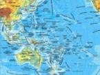
Surface ocean currents. Map of the currents of the world's oceans. Reasons for the formation of currents in the oceans
Marine (oceanic) or simply currents are the translational movements of water masses in the oceans and seas over distances measured in hundreds and thousands of kilometers, due to various forces (gravitational, friction, tide-forming).
There are several classifications of sea currents in the oceanological scientific literature. According to one of them, currents can be classified according to the following criteria (Fig. 1.1.):
1. according to the forces that cause them, that is, according to their origin (genetic classification);
2. stability (variability);
3. by location depth;
4. by the nature of the movement;
5. according to physical and chemical properties.
The main one is the genetic classification, in which three groups of currents are distinguished.
1. In the first group of genetic classification - gradient currents due to horizontal hydrostatic pressure gradients. There are the following gradient currents:
Density, due to the horizontal density gradient (uneven distribution of temperature and salinity of water, and, consequently, density horizontally);
compensation, due to the slope of the sea level, which arose under the influence of the wind;
Barogradient, due to uneven atmospheric pressure above sea level;
· runoff, formed as a result of an excess of water in any area of the sea, as a result of the inflow of river water, heavy precipitation or ice melting;
· seiche, arising from seiche vibrations of the sea (fluctuations in the water of the entire basin as a whole).
Currents that exist when the horizontal gradient of hydrostatic pressure and the Coriolis force are in equilibrium are called geostrophic.
The second group of gradient classification includes currents caused by the action of the wind. They are divided into:
Drift winds are created by prolonged, or prevailing, winds. These include the trade winds of all oceans and the circumpolar current in the southern hemisphere (the current of the West Winds);
wind, caused not only by the action of the direction of the wind, but also by the slope of the level surface and the redistribution of water density caused by the wind.
The third group of classification gradients includes tidal currents caused by tidal phenomena. These currents are most noticeable near the coast, in shallow waters, in the mouths of rivers. They are the strongest.
As a rule, total currents are observed in the oceans and seas, due to the combined action of several forces. Currents that exist after the cessation of the action of the forces that caused the movement of water are called inertial. Under the action of friction forces, inertial flows gradually fade.
2. According to the nature of stability, variability, currents are distinguished as periodic and non-periodic (stable and unstable). Currents, changes of which occur with a certain period, are called periodic. These include tidal currents that vary mainly with a period of approximately half a day (semidiurnal tidal currents) or days (diurnal tidal currents).
Rice. 1.1. Classification of currents of the oceans
Currents whose changes do not have a clear periodic character are usually called non-periodic. They owe their origin to random, unexpected causes (for example, the passage of a cyclone over the sea causes non-periodic wind and barometric currents).
There are no permanent currents in the strict sense of the word in the oceans and seas. Relatively little changing currents in direction and speed for the season are monsoon, for the year - trade winds. A flow that does not change with time is called steady flow, and a flow that changes with time is called unsteady flow.
3. According to the depth of location, surface, deep and near-bottom currents are distinguished. Surface currents are observed in the so-called navigation layer (from the surface to 10 - 15 m), near-bottom currents are near the bottom, and deep ones - between the surface and near-bottom currents. The speed of movement of surface currents is highest in the uppermost layer. Deeper it goes down. Deep waters move much more slowly, and the speed of movement of bottom waters is 3–5 cm/s. The speed of the currents is not the same in different regions of the ocean.
4. According to the nature of the movement, meandering, rectilinear, cyclonic and anticyclonic currents are distinguished. Meandering currents are called currents that do not move in a straight line, but form horizontal undulating bends - meanders. Due to the instability of the flow, meanders can separate from the flow and form independently existing eddies. Rectilinear currents are characterized by the movement of water in relatively straight lines. Circular currents form closed circles. If the movement in them is directed counterclockwise, then these are cyclonic currents, and if clockwise, then they are anticyclonic (for the northern hemisphere).
5. According to the nature of physical and chemical properties, warm, cold, neutral, salty and fresh water currents are distinguished (the division of currents according to these properties is to a certain extent conditional). To assess the specified characteristic of the current, its temperature (salinity) is compared with the temperature (salinity) of the surrounding waters. Thus, a warm (cold) flow is a water temperature in which the temperature of the surrounding waters is higher (lower). For example, the deep current of Atlantic origin in the Arctic Ocean has a temperature of about 2 °C, but belongs to warm currents, and the Peruvian current off the western coast of South America, which has a water temperature of about 22 °C, belongs to cold currents.
The main characteristics of the sea current: speed and direction. The latter is determined in the reverse way compared to the direction of the wind, i.e. in the case of the current, where the water flows, while in the case of the wind, where it blows from. Vertical movements of water masses are usually not taken into account when studying sea currents, since they are not large.
In the oceans there is a single, interconnected system of main stable currents (Fig. 1.2.), which determines the transfer and interaction of waters. This system is called oceanic circulation.
The main force that drives the surface waters of the ocean is the wind. Therefore, surface currents should be considered with prevailing winds.
Within the southern periphery of the oceanic anticyclones of the northern hemisphere and the northern periphery of the southern hemisphere anticyclones (the centers of anticyclones are located at 30 - 35 ° north and south latitude), a system of trade winds operates, under the influence of which stable powerful surface currents are formed, directed to the west (North and South trade winds). currents). Encountering the eastern shores of the continents on their way, these currents create a rise in level and turn to high latitudes (Guiana, Brazil, etc.). In temperate latitudes (about 40°) westerly winds predominate, which intensifies currents going to the east (North Atlantic, North Pacific, etc.). In the eastern parts of the oceans between 40 and 20 ° north and south latitude, the currents are directed towards the equator (Canary, California, Benguela, Peru, etc.).
Thus, stable water circulation systems are formed in the oceans north and south of the equator, which are giant anticyclonic gyres. Thus, in the Atlantic Ocean, the northern anticyclonic gyre extends from south to north from 5 to 50° north latitude and from east to west from 8 to 80° west longitude. The center of this cycle is shifted relative to the center of the Azores anticyclone to the west, which is explained by the increase in the Coriolis force with latitude. This leads to the intensification of currents in the western parts of the oceans, creating conditions for the formation of such powerful currents as the Gulf Stream in the Atlantic and Kuroshio in the Pacific Ocean.
A peculiar division between the North and South trade winds is the Intertrade countercurrent, which carries its waters to the east.
In the northern part of the Indian Ocean, the Hindustan peninsula, which protrudes deeply to the south, and the vast Asian continent create favorable conditions for the development of monsoon circulation. In November - March, the northeast monsoon is observed here, and in May - September - southwest. In this regard, currents north of 8° south latitude have a seasonal course, following the seasonal course of atmospheric circulation. In winter, the western monsoon current is observed at the equator and north of it, i.e., during this season, the direction of surface currents in the northern part of the Indian Ocean corresponds to the direction of currents in other oceans. At the same time, in the zone separating the monsoon and trade winds (3 - 8 ° south latitude), a surface equatorial countercurrent develops. In summer, the western monsoon current is replaced by an eastern one, and the equatorial countercurrent is replaced by weak and unstable currents.
Rice. 1.2.
In temperate latitudes (45 - 65 °) in the northern part of the Atlantic and Pacific oceans, counterclockwise circulation takes place. However, due to the instability of the atmospheric circulation in these latitudes, the currents are also characterized by low stability. In the band 40 - 50 ° south latitude is the Atlantic circumpolar current directed to the east, also called the current of the West Winds.
Off the coast of Antarctica, the currents are predominantly westward and form a narrow strip of coastal circulation along the shores of the mainland.
The North Atlantic Current penetrates into the Arctic Ocean basin in the form of branches of the Norwegian, North Cape and Svalbard currents. In the Arctic Ocean, surface currents are directed from the shores of Asia across the pole to the eastern shores of Greenland. This nature of the currents is caused by the predominance of easterly winds and the compensation of the inflow in the deep layers of the Atlantic waters.
In the ocean, zones of divergence and convergence are distinguished, characterized by the divergence and convergence of surface jets of currents. In the first case, the water rises; in the second, it sinks. Of these zones, convergence zones are more clearly distinguished (for example, the Antarctic convergence at 50 - 60 ° south latitude).
Let us consider the features of the circulation of the waters of individual oceans and the characteristics of the main currents of the World Ocean (table).
In the northern and southern parts of the Atlantic Ocean, in the surface layer, there are closed circulations of currents with centers near 30 ° north and south latitude. (The circulation in the northern part of the ocean will be discussed in the next chapter).
The main currents of the oceans
|
Name |
Temperature gradation |
Sustainability |
Average speed, cm/s |
|
northern trade wind |
Neutral |
sustainable |
|
|
Mindanao |
Neutral |
sustainable |
|
|
Very stable |
|||
|
North Pacific |
Neutral |
sustainable |
|
|
sustainable |
|||
|
Aleutian |
Neutral |
unstable |
|
|
Kuril-Kamchatskoe |
Cold |
sustainable |
|
|
california |
Cold |
unstable |
|
|
Intertrade countercurrent |
Neutral |
sustainable |
|
|
southern trade wind |
Neutral |
sustainable |
|
|
East Australian |
sustainable |
||
|
South Pacific |
Neutral |
unstable |
|
|
Peruvian |
Cold |
Weakly stable |
|
|
El Niño |
Weakly stable |
||
|
Antarctic circumpolar |
Neutral |
sustainable |
|
|
Indian |
|||
|
southern trade wind |
Neutral |
sustainable |
|
|
Cape Agulhas |
Very stable |
||
|
Western Australian |
Cold |
unstable |
|
|
Antarctic circumpolar |
Neutral |
sustainable |
|
|
Northern |
arctic |
||
|
Norwegian |
sustainable |
||
|
West Spitsbergen |
sustainable |
||
|
East Greenland |
Cold |
sustainable |
|
|
West Greenland |
sustainable |
||
|
Atlantic |
|||
|
northern trade wind |
Neutral |
sustainable |
|
|
Gulfstream |
Very stable |
||
|
North Atlantic |
Very stable |
||
|
Canarian |
Cold |
sustainable |
|
|
Irminger |
sustainable |
||
|
Labrador |
Cold |
sustainable |
|
|
Intertrade countercurrent |
Neutral |
sustainable |
|
|
southern trade wind |
Neutral |
sustainable |
|
|
brazilian |
sustainable |
||
|
Benguela |
Cold |
sustainable |
|
|
Falkland |
Cold |
sustainable |
|
|
Antarctic circumpolar |
Neutral |
sustainable |
In the southern part of the ocean, the warm Brazilian current carries water (at a speed of up to 0.5 m/s) far to the south, and the Benguela current, branched off from the powerful current of the West Winds, closes the main circulation in the southern part of the Atlantic Ocean and brings cold water to the coast of Africa.
The cold waters of the Falkland Current penetrate the Atlantic, rounding Cape Horn and pouring between the shore and the Brazil Current.
A feature in the circulation of the waters of the surface layer of the Atlantic Ocean is the presence of the Lomonosov subsurface equatorial countercurrent, which moves along the equator from west to east under a relatively thin layer of the South trade wind current (depth from 50 to 300 m) at a speed of up to 1 - 1.5 m/s. The current is stable in direction and exists in all seasons of the year.
Geographical position, climatic features, water circulation systems and good water exchange with Antarctic waters determine the hydrological conditions of the Indian Ocean.
In the northern part of the Indian Ocean, unlike other oceans, the monsoonal circulation of the atmosphere causes a seasonal change in surface currents north of 8 ° south latitude. In winter, the Western Monsoon Current is observed at a speed of 1 - 1.5 m/s. In this season, the Equatorial countercurrent develops (in the zone of separation of the Monsoon and South trade winds) and disappears.
Compared to other oceans in the Indian Ocean, the zone of prevailing southeast winds, under the influence of which the South Trade Wind Current arises, is shifted to the south, so this current moves from east to west (speed 0.5 - 0.8 m / s) between 10 and 20° south latitude. Off the coast of Madagascar, the South Tradewind current splits. One of its branches runs north along the coast of Africa to the equator, where it turns east and in winter gives rise to the Equatorial Countercurrent. In summer, the northern branch of the South Trade Wind Current, moving along the coast of Africa, gives rise to the Somali Current. Another branch of the South Trade Wind Current off the coast of Africa turns south and, under the name of the Mozambique Current, moves along the coast of Africa to the southwest, where its branch gives rise to the Cape Agulhas Current. Most of the Mozambique Current turns east and joins the West Wind Current, from which the West Australian Current branches off off the coast of Australia, completing the circulation of the southern Indian Ocean.
The insignificant inflow of Arctic and Antarctic cold waters, the geographic position and the system of currents determine the features of the hydrological regime of the Pacific Ocean.
A characteristic feature of the general scheme of the surface currents of the Pacific Ocean is the presence of large water cycles in its northern and southern parts.
In the trade winds, under the influence of constant winds, the South and North trade winds arise, going from east to west. Between them, from west to east, the Equatorial (Intertrade) countercurrents move with speeds of 0.5 - 1 m / s.
The northern trade wind current near the Philippine Islands is divided into several branches. One of them turns south, then east and gives rise to the Equatorial (Intertrade) countercurrent. The main branch follows north along the island of Taiwan (Taiwan current), then turns to the northeast and under the name Kuroshio passes along the eastern coast of Japan (speed up to 1 - 1.5 m / s) to Cape Nojima (Honshu Island). Further, it deviates to the east and crosses the ocean as the North Pacific Current. A characteristic feature of the Kuroshio Current, like the Gulf Stream, is meandering and displacement of its axis either to the south or to the north. Off the coast of North America, the North Pacific Current bifurcates into the California Current, directed to the south and closing the main cyclonic circulation of the North Pacific Ocean, and the Alaska Current, going to the north.
The cold Kamchatka Current originates in the Bering Sea and flows along the shores of Kamchatka, the Kuril Islands (Kuril Current), and the coast of Japan, pushing the Kuroshio Current to the east.
The southern trade wind current moves to the west (velocity 0.5 - 0.8 m/s) with numerous branches. Off the coast of New Guinea, part of the flow turns north and then east and, together with the southern branch of the North Trade Wind Current, gives rise to the Equatorial (Intertrade) countercurrent. Most of the South Trade Wind Current is deflected, forming the East Australian Current, which then flows into the powerful West Wind Current, from which the cold Peruvian Current branches off off the coast of South America, completing the circulation in the South Pacific Ocean.
In the summer period of the southern hemisphere, towards the Peruvian current from the Equatorial countercurrent, the warm El Niño current moves south to 1 - 2 ° south latitude, penetrating in some years to 14 - 15 ° south latitude. Such an intrusion of the warm waters of El Niño into the southern regions of the coast of Peru leads to catastrophic consequences due to an increase in the temperature of water and air (heavy showers, death of fish, epidemics).
A characteristic feature in the distribution of currents in the surface layer of the ocean is the presence of the Equatorial subsurface countercurrent - the Cromwell Current. It crosses the ocean along the equator from west to east at a depth of 30 to 300 m at a speed of up to 1.5 m/s. The current covers a strip with a width from 2° north latitude to 2° south latitude.
The most characteristic feature of the Arctic Ocean is that its surface is covered with floating ice throughout the year. The low temperature and salinity of the waters favor the formation of ice. Coastal waters are free of ice only in summer, for two to four months. In the central part of the Arctic, mainly heavy multi-year ice (pack ice) with a thickness of more than 2 - 3 m, covered with numerous hummocks, is observed. In addition to multi-year ice, there are one-year and two-year ice. A rather wide (tens and hundreds of meters) strip of fast ice forms along the Arctic shores in winter. There are no ices only in the area of the warm Norwegian, North Cape and Svalbard currents.
Under the influence of winds and currents, the ice in the Arctic Ocean is in constant motion.
Well-defined areas of cyclonic and anticyclonic water circulation are observed on the surface of the Arctic Ocean.
Under the influence of the polar baric maximum in the Pacific part of the Arctic Basin and the hollow of the Icelandic minimum, a general Transarctic current arises. It carries out the general movement of waters from east to west throughout the polar area. The Transarctic Current originates from the Bering Strait and goes to the Fram Strait (between Greenland and Svalbard). Its continuation is the East Greenland current. Between Alaska and Canada there is an extensive anticyclonic water cycle. The cold Baffin Current is formed mainly due to the removal of Arctic waters through the straits of the Canadian Arctic Archipelago. Its continuation is the Labrador Current.
The average speed of water movement is about 15 - 20 cm / s.
A cyclonic, very intense circulation occurs in the Norwegian and Greenland Seas in the Atlantic part of the Arctic Ocean.
Navigators learned about the presence of ocean currents almost immediately, as soon as they began to surf the waters of the oceans. True, the public paid attention to them only when, thanks to the movement of ocean waters, many great geographical discoveries were made, for example, Christopher Columbus sailed to America thanks to the North Equatorial Current. After that, not only sailors, but also scientists began to pay close attention to ocean currents and strive to explore them as best and as deeply as possible.
Already in the second half of the XVIII century. the sailors studied the Gulf Stream quite well and successfully applied their knowledge in practice: they went with the flow from America to Great Britain, and kept a certain distance in the opposite direction. This allowed them to be two weeks ahead of ships whose captains were not familiar with the terrain.
Oceanic or sea currents are large-scale movements of the water masses of the World Ocean at a speed of 1 to 9 km / h. These streams do not move randomly, but in a certain channel and direction, which is the main reason why they are sometimes called the rivers of the oceans: the width of the largest currents can be several hundred kilometers, and the length can reach more than one thousand.
It has been established that water flows do not move straight, but deviating slightly to the side, they obey the Coriolis force. In the Northern Hemisphere they almost always move clockwise, in the Southern Hemisphere it is vice versa.. At the same time, currents located in tropical latitudes (they are called equatorial or trade winds) move mainly from east to west. The strongest currents were recorded along the eastern coasts of the continents.
Water flows do not circulate by themselves, but they are set in motion by a sufficient number of factors - the wind, the rotation of the planet around its axis, the gravitational fields of the Earth and the Moon, the bottom topography, the outlines of continents and islands, the difference in temperature indicators of water, its density, depth in various places of the ocean and even its physico-chemical composition.
Of all the types of water flows, the most pronounced are the surface currents of the World Ocean, the depth of which is often several hundred meters. Their occurrence was influenced by trade winds, constantly moving in tropical latitudes in a west-east direction. These trade winds form huge streams of the North and South Equatorial currents near the equator. A smaller part of these flows returns to the east, forming a countercurrent (when the movement of water occurs in the opposite direction from the movement of air masses). Most, colliding with the continents and islands, turns to the north or south.
Warm and cold water streams
It must be taken into account that the concepts of "cold" or "warm" currents are conditional definitions. So, despite the fact that the temperature indicators of the water flows of the Benguela Current, which flows along the Cape of Good Hope, are 20 ° C, it is considered cold. But the North Cape Current, which is one of the branches of the Gulf Stream, with temperatures ranging from 4 to 6 ° C, is warm.


This happens because the cold, warm and neutral currents got their names based on a comparison of the temperature of their water with the temperature indicators of the ocean surrounding them:
- If the temperature indicators of the water flow coincide with the temperature of the waters surrounding it, such a flow is called neutral;
- If the temperature of the currents is lower than the surrounding water, they are called cold. They usually flow from high latitudes to low latitudes (for example, the Labrador Current), or from areas where, due to the large flow of rivers, ocean water has a reduced salinity of surface waters;
- If the temperature of the currents is warmer than the surrounding water, then they are called warm. They move from the tropics to subpolar latitudes, such as the Gulf Stream.
Main water flows
At the moment, scientists have recorded about fifteen major oceanic water flows in the Pacific, fourteen in the Atlantic, seven in the Indian and four in the Arctic Ocean.
It is interesting that all the currents of the Arctic Ocean move at the same speed - 50 cm / s, three of them, namely the West Greenland, West Svalbard and Norwegian, are warm, and only the East Greenland belongs to the cold current.
But almost all the oceanic currents of the Indian Ocean are warm or neutral, while the Monsoon, Somali, West Australian and the Cape of Needles (cold) move at a speed of 70 cm / s, the speed of the rest varies from 25 to 75 cm / s. The water flows of this ocean are interesting because, along with the seasonal monsoon winds, which change their direction twice a year, ocean rivers also change their course: in winter they mainly flow west, in summer - east (a phenomenon characteristic only of the Indian Ocean). ).
Since the Atlantic Ocean stretches from north to south, its currents also have a meridional direction. Water streams located in the north move clockwise, in the south - against it.


A striking example of the flow of the Atlantic Ocean is the Gulf Stream, which, starting in the Caribbean Sea, carries warm waters to the north, breaking up into several side streams along the way. When the waters of the Gulf Stream end up in the Barents Sea, they enter the Arctic Ocean, where they cool and turn south in the form of a cold Greenland current, after which at some stage they deviate to the west and again adjoin the Gulf Stream, forming a vicious circle.
The currents of the Pacific Ocean are mainly latitudinal and form two huge circles: northern and southern. Since the Pacific Ocean is extremely large, it is not surprising that its water flows have a significant impact on most of our planet.
For example, the trade winds move warm water from the western tropical coasts to the eastern ones, which is why the western part of the Pacific Ocean in the tropical zone is much warmer than the opposite side. But in the temperate latitudes of the Pacific Ocean, on the contrary, the temperature is higher in the east.
deep currents
For quite a long time, scientists believed that the deep ocean waters were almost motionless. But soon, special underwater vehicles discovered both slow and fast-flowing water flows at great depths.
For example, under the Equatorial Pacific Ocean at a depth of about one hundred meters, scientists have identified the Cromwell underwater stream, moving eastward at a speed of 112 km / day.
A similar movement of water flows, but already in the Atlantic Ocean, was found by Soviet scientists: the width of the Lomonosov current is about 322 km, and the maximum speed of 90 km / day was recorded at a depth of about one hundred meters. After that, another underwater stream was discovered in the Indian Ocean, however, its speed turned out to be much lower - about 45 km / day.
The discovery of these currents in the ocean gave rise to new theories and mysteries, the main of which is the question of why they appeared, how they formed, and whether the entire ocean area is covered by currents or there is a point where the water is still.
The influence of the ocean on the life of the planet
The role of ocean currents in the life of our planet cannot be overestimated, since the movement of water flows directly affects the planet's climate, weather, and marine organisms. Many compare the ocean to a huge heat engine powered by solar energy. This machine creates a continuous water exchange between the surface and deep layers of the ocean, providing it with oxygen dissolved in water and affecting the life of marine life.
This process can be traced, for example, by considering the Peruvian Current, which is located in the Pacific Ocean. Thanks to the rise of deep waters, which raise phosphorus and nitrogen, animal and plant plankton successfully develop on the ocean surface, as a result of which the food chain is organized. Plankton is eaten by small fish, which, in turn, becomes a victim of larger fish, birds, marine mammals, which, with such food abundance, settle here, making the region one of the most highly productive areas of the World Ocean.
It also happens that a cold current becomes warm: the average ambient temperature rises by several degrees, which causes warm tropical showers to fall on the ground, which, once in the ocean, kill fish accustomed to cold temperatures. The result is deplorable - a huge amount of dead small fish ends up in the ocean, large fish leave, fishing stops, birds leave their nests. As a result, the local population is deprived of fish, crops that were beaten by downpours, and profits from the sale of guano (bird droppings) as fertilizer. It can often take several years to restore the former ecosystem.
NASA specialists have created a new map of the currents of the world's oceans. Its difference from all previous ones is in interactivity - anyone can independently look at all stable water flows and determine the temperature nature of the flow.
Did you know that ocean water is not uniform? It is logical that closer to the surface it is warmer than at depth. However, not everyone knows that the volume of salt in ocean water, with rare exceptions, is inversely proportional to the depth at which this water is located - the deeper, the fresher. However, there are exceptions to this rule. For example, in the Arctic and Antarctic, deep waters are also saturated with salt - ice layers penetrating to great depths contain particles of surface salt evaporation, enriching the entire water layer with them.
The top layer of ocean water is driven by stable air currents. Thus, the map of ocean currents is generally identical to the map of sea winds.
Unique online map
A unique map with which you can see in detail the currents of all the oceans of the world
The model was developed to demonstrate the mechanism of thermal circulation in the world's waters. However, the map is not absolutely accurate - in order to better demonstrate the difference between surface and deep water flows, at certain times the depth indicator is somewhat overestimated in relation to the real one.
The animation component of the new map was modeled by NASA scientists at the Goddard Space Flight Center laboratory.
Comparative contour map of currents
Below is a classic contour map of the currents of the world ocean in Russian, which schematically displays all the main cold and warm currents of the world ocean. The arrows indicate the direction of movement, and the color indicates the temperature characteristic of the water - warm or cold is a particular current.

Answer left Guru
ocean currents
Atlantic Ocean
The northern trade wind current is warm………………… (Sptt)
The Gulf Stream is warm …………………………. (gtt)
The Antilles current is warm …………………… ……… (Att)
The North Atlantic Current is warm…………… (Satt)
The Caribbean current is warm……………………………. (Kartt)
The Lomonosov Current is warm…………………………… (TLT)
The Guinean current is warm ……………………………(Gwth)
The Brazilian current is warm ………………………….(Brtt)
The Canary current is cold ………………………. (Kanth)
Labrador current is cold ………………… (Labth)
The Bengal current is cold ……………………. (Benth)
The Falkland Current is cold…………………… (Folth)
The course of the western winds is cold ……………… .. (Твх)
Indian Ocean
The monsoon current is warm………………………………… (Tmt)
The south trade wind current is warm …………………… (Yuptt)
The Madagascar current is warm………………….. (Madtt)
The Somali current is cold…………………… (Somth)
The course of the western winds is cold………………… (Twvh)
Pacific Ocean
The North Pacific current is warm…………. (Sttt)
The Alaska current is warm ……………………………(Att)
The Kuroshio current is warm …………………………………(TKt)
The trade wind countercurrent is warm……………. (Mprt)
South trade wind current is warm …………………….(Yuptt)
Cromwell current, warm ………………………………(TKt)
East Australian current warm………… (WAth)
The California current is cold………………… (Kalth)
The Peruvian current is cold ………………………(Perth)
The course of the western winds is cold………….…….. (Tzvh)
Arctic Ocean
Svalbard current is warm ……………………..(Shtt)
The Norwegian current is warm……………………….…… (Ntt)
East Greenland Current is cold………(VGth)
Notes: 1. The Pacific Ocean has fewer currents than the Atlantic Ocean.
(15 currents in the Atlantic, 10 in the Pacific, 5 in the Indian and 3 in the North. Total: 33 currents.
Of these: 22 are warm, 11 are cold).
2. The cold westerly wind current (Twwh) covers three oceans.
3. The warm south-trade current (Juptt) also flows through three oceans.
4. Warm trade wind countercurrents (Mprt) are located in two large oceans:
in the Pacific and Atlantic.
5. Warm northern currents (Atlantic and Pacific) - are available in two oceans.
6. In the Atlantic Ocean: 10 warm currents, 5 cold.
In the Pacific Ocean: 7-warm, 3-cold.
In the Indian Ocean: 3-warm, 2-cold.
In the Northern Ocean: 2-warm, 1-cold.
Answer left a guest
North trade wind current warm Gulf Stream current warm Antilles current warm North Atlantic current warm Caribbean current warm Intertrade countercurrent warm South trade wind current warm Lomonosov current warm Guinea current warm Brazil current warm Canary current cold Labrador current cold Bengal current cold Falkland current cold West wind current cold Monsoon current warm South trade wind current warm Madagascar current warm Somali current cold West wind current cold North Pacific current warm Alaska current warm Kuroshio current warm Equatorial countercurrent warm South trade wind current warm Cromwell Current, warm East Australian current warm California current cold Peruvian current cold West wind current cold Svalbard current warm Norwegian current warm East Greenland current cold
The fastest and coldest current in the southern hemisphere of the Earth
New deep current
A new deep-sea current was discovered by oceanologists. This current owes its formation to the melting of glaciers, which has only intensified recently. It carries cold waters from the coast of Antarctica to the most equatorial latitudes - this is exactly what Japanese and Australian scientists told the world when they published the results of their research in the journal Nature Geoscience.
According to the observations of scientists, glacial melt water enters the Ross Sea and keeps its course east to the underwater Kerguelen Plateau, located 3,000 km southwest of the Australian continent. The waters are then literally thrown into the ocean in a fast current. This relatively small and narrow stream, no more than 50 km wide, originates at a depth of 3 km. Its temperature is almost 0 degrees, or more precisely - 0.2 oC.
Current speed 700 meters per hour
Scientists have been looking at this current for almost two years and found that it is capable of carrying 30 million cubic meters of water in just one second, that is, its speed is no less than 700 m/h. Another, the same cold and fast current, located in the Southern Ocean, has not yet been found.
It is very difficult to identify and study such currents. In addition to the time spent, the researchers needed 30 impressive automatic stations, which had to be placed along the entire proposed current, and then regularly collect and process the readings of these stations, analyzing literally everything. After a two-year stay on the seabed, the specialists removed them and again carefully compared and studied all the indicators of the devices.

Currents as an indicator of planetary health
This discovery, as scientists say, helps us to study the mechanism of interaction between melting glaciers and the waters of the oceans, which is still largely a mystery to people, and also to better understand how the oceans will react to the increasing concentration of carbon dioxide in the atmosphere.
It is worth noting that the Gulf Stream is the most powerful warm current in the world ocean, and the West Wind Drift is considered the most powerful current in the world.
Victoria Fabisek, Samogo.Net

Warm and cold currents
Sea currents (ocean currents) - translational movements of water masses in the seas and oceans, due to various forces (the action of the friction force between water and air, pressure gradients arising in water, tide-forming forces of the Moon and the Sun). The direction of sea currents is greatly influenced by the rotation of the Earth, which deflects currents in the Northern Hemisphere to the right, in the Southern Hemisphere - to the left.
Sea currents are caused either by the friction of the wind on the sea surface (wind currents), or by the uneven distribution of temperature and salinity of the water (density currents), or by the level slope (runoff currents). By the nature of variability, there are constant, temporary and periodic (tidal origin), by location - surface, subsurface, intermediate, deep and near-bottom. By physical and chemical properties - desalinated and salty.
Warm and cold sea currents
In these currents, the water temperature is respectively higher or lower than the ambient temperature. Warm currents are directed from low to high latitudes (for example, the Gulf Stream), cold currents are directed from high to low (Labrador). Currents with the temperature of the surrounding waters are called neutral.
The temperature of the current is considered relative to the surrounding waters. A warm current has a water temperature several degrees higher than the surrounding ocean water. Cold flow is the opposite. Warm currents usually move from warmer latitudes to colder latitudes, while cold ones do the opposite. You already know that currents significantly affect the climate of the coasts. Thus, warm currents increase the air temperature by 3-5 0C and increase the amount of precipitation. Cold currents lower temperatures and reduce rainfall.
On geographic maps, warm currents are shown with red arrows, cold ones with blue arrows.
The Gulf Stream is one of the largest warm currents in the Northern Hemisphere. It passes through the Gulf of Mexico (eng. Gulf Stream - the Gulf) and carries the warm tropical waters of the Atlantic Ocean to high latitudes. This giant stream of warm water largely determines the climate of Europe, making it soft and warm. Every second, the Gulf Stream carries 75 million tons of water (for comparison: the Amazon, the most full-flowing river in the world, is 220 thousand tons of water). At a depth of about 1 km under the Gulf Stream, a countercurrent is observed.
Note another current in the Atlantic - the North Atlantic. It runs across the ocean to the east, towards Europe. The North Atlantic Current is less powerful than the Gulf Stream. The water flow here is from 20 to 40 million cubic meters per second, and the speed is from 0.5 to 1.8 km/h, depending on the location.
However, the influence of the North Atlantic Current on the climate of Europe is very noticeable. Together with the Gulf Stream and other currents (Norwegian, North Cape, Murmansk), the North Atlantic Current softens the climate of Europe and the temperature regime of the seas washing it. Only one warm current, the Gulf Stream, cannot have such an impact on the climate of Europe: after all, the existence of this current ends thousands of kilometers from the coast of Europe.
In the Pacific Ocean, off the coast of South America, the cold Peruvian current passes. The air masses that form above its cold waters are not saturated with moisture and do not bring precipitation to land. As a result, there is no precipitation on the coast for several years, which led to the emergence of the Atacama Desert there.
The most powerful current of the World Ocean is the cold current of the West Winds, also called the Antarctic circumpolar (from lat. cirkum - around). The reason for its formation are strong and stable westerly winds blowing from west to east over vast expanses of the Southern Hemisphere from temperate latitudes to the coast of Antarctica. This current covers a zone 2500 km wide, extends to a depth of more than 1 km and carries up to 200 million tons of water every second. There are no large land masses on the path of the Western Winds, and it connects in its circular flow the waters of three oceans - the Pacific, Atlantic and Indian.
Water masses that continuously move through the oceans are called currents. They are so strong that no continental river can compare with them.
What are the types of currents?
A few years ago, only currents moving along the surface of the seas were known. They are called superficial. They flow at a depth of up to 300 meters. Now we know that deep currents arise in deeper areas.
How do surface currents occur?
Surface currents are caused by constantly blowing winds - trade winds - and reach speeds of 30 to 60 kilometers per day. These include equatorial currents (directed to the west), off the eastern coast of the continents (directed towards the poles) and others.
What are trade winds?
The trade winds are air currents (winds) that are stable throughout the year in the tropical latitudes of the oceans. In the Northern Hemisphere, these winds are directed from the northeast, in the Southern Hemisphere - from the southeast. Due to the rotation of the Earth, they always deviate to the west. The winds that blow in the Northern Hemisphere are called the northeast trade winds, and in the Southern Hemisphere they are called the southeast. Sailing ships use these winds to reach their destination faster.
What are equatorial currents?
Trade winds blow constantly and so strongly that they divide the ocean waters on both sides of the equator into two powerful westerly currents, which are called equatorial. On the way, they have the eastern coasts of parts of the world, so these currents change direction to the north and south. Then they fall into other wind systems and break up into small currents.
How do deep currents form?
Deep currents, unlike surface currents, are not caused by winds, but by other forces. They depend on the density of water: cold and salty water is denser than warm and less salty, and therefore sinks lower to the seabed. Deep currents are caused by the fact that the cooled salt water in the northern latitudes sinks and continues to move above the seabed. A new, warm surface current begins its movement from the south. A cold deep current carries water towards the equator, where it warms up again and rises up. Thus, a cycle is formed. Deep currents move slowly, so it sometimes takes years before they rise to the surface.
What is worth knowing about the equator?
The equator is an imaginary line that passes through the center of the Earth perpendicular to the axis of its rotation, that is, it is equally distant from both poles and divides our planet into two hemispheres - Northern and Southern. The length of this line is about 40,075 kilometers. The equator is located at the zero degree of geographic latitude.
Why does the salt content of sea water change?
The salt content of sea water increases when the water evaporates or freezes. There is a lot of ice in the North Atlantic Ocean, so the water there is saltier and colder than at the equator, especially in winter. However, the salinity of warm water increases with evaporation, as salt remains in it. The salt content decreases when, for example, ice melts in the North Atlantic and fresh water flows into the sea.
What are deep currents?
Deep currents carry cold water from the polar regions to warm tropical countries, where the water masses mix. The rise of cold water affects the coastal climate: rain falls directly on the cold water. The air comes to the warm mainland almost dry, so the rains stop and deserts appear on the coastal shores. This is how the Namib Desert on the South African coast arose.
What is the difference between cold and warm currents?
Depending on the temperature, sea currents are divided into warm and cold. The first appear near the equator. They carry warm waters through cold waters located near the poles and heat the air. Counter sea currents flowing from the polar regions towards the equator transport cold waters through the surrounding warm ones, and as a result, the air cools. Sea currents are like a huge air conditioner that distributes cold and warm air around the globe.
What are burs?
Bors are called tidal waves, which can be observed in those places where rivers flow into the sea - that is, at the mouths. They arise when so many waves running towards the shore accumulate in a shallow and wide funnel-shaped mouth that they all suddenly pour into the river. In the Amazon, one of the South American rivers, the surf raged so much that a five-meter wall of water advanced more than a hundred kilometers deep into the mainland. Bors also appear in the Seine (France), the Ganges Delta (India) and on the coast of China.
Alexander von Humboldt (1769-1859)
The German naturalist and scientist Alexander von Humboldt traveled extensively in Latin America. In 1812, he discovered that a cold deep current moves from the polar regions to the equator and cools the air there. In his honor, the current that carries water along the coasts of Chile and Peru was named the Humboldt Current.
Where are the largest warm sea currents on the planet?
The largest warm sea currents include the Gulf Stream (Atlantic Ocean), Brazilian (Atlantic Ocean), Kuroshio (Pacific Ocean), Caribbean (Atlantic Ocean), North and South Equatorial Currents (Atlantic, Pacific and Indian Oceans), as well as Antilles (Atlantic Ocean).
Where are the biggest cold sea currents located?
The largest cold sea currents are Humboldt (Pacific Ocean), Canary (Atlantic Ocean), Oyashio, or Kuril (Pacific Ocean), East Greenland (Atlantic Ocean), Labrador (Atlantic Ocean) and California (Pacific Ocean).
How do sea currents affect climate?
Warm sea currents primarily affect the surrounding air masses and, depending on the geographical position of the continent, warm the air. So, thanks to the Gulf Stream in the Atlantic Ocean, the temperature in Europe is 5 degrees higher than it could be. Cold currents, which are directed from the polar regions to the equator, on the contrary, lead to a decrease in air temperature.
What is affected by changes in the sea current?
Sea currents can be affected by sudden events such as volcanic eruptions or changes associated with El Niño. El Niño is a warm water current that can displace a cold current off the coast of Peru and Ecuador in the Pacific Ocean. Although the influence of El Niño is limited to certain areas, its effects affect the climate of outlying regions. It causes heavy rainfall along the coasts of South America and East Africa, resulting in devastating floods, storms and landslides. In contrast, tropical rainforests around the Amazon experience a dry climate that reaches Australia, Indonesia, and South Africa, causing droughts and wildfires. Off the Peruvian coast, El Niño is leading to mass extinction of fish and corals as plankton, which lives predominantly in cold water, suffers when it warms up.
How far can sea currents carry objects out to sea?
Sea currents can carry objects that have fallen into the water for great distances. So, for example, wine bottles can be found in the sea, which 30 years ago were thrown from ships in the ocean between South America and Antarctica and carried away for thousands of kilometers. The currents carried them across the Pacific and Indian oceans!
What is worth knowing about the Gulf Stream?
The Gulf Stream is one of the most powerful and famous sea currents that originates in the Gulf of Mexico and carries warm waters to the Svalbard archipelago. Thanks to the warm waters of the Gulf Stream, northern Europe has a mild climate, although it should be much colder here, since this area is located as far north as Alaska, where it is freezing cold.
What are sea currents - video